You are here: Home > Network List > TA - USArray Transportable Network (new EarthScope stations) Stations List
> Station G05D Wamic, OR, USA > Earthquake Result Viewer
G05D Wamic, OR, USA - Earthquake Result Viewer
| Earthquake location: |
Off East Coast Of Honshu, Japan |
| Earthquake latitude/longitude: |
38.0/143.2 |
| Earthquake time(UTC): |
2011/03/11 (070) 06:46:31 GMT |
| Earthquake Depth: |
31 km |
| Earthquake Magnitude: |
5.9 MB |
| Earthquake Catalog/Contributor: |
WHDF/NEIC |
|
| Network: |
TA USArray Transportable Network (new EarthScope stations) |
| Station: |
G05D Wamic, OR, USA |
| Lat/Lon: |
45.24 N/121.32 W |
| Elevation: |
592 m |
|
| Distance: |
67.6 deg |
| Az: |
49.512 deg |
| Baz: |
301.684 deg |
| Ray Param: |
0.0567852 |
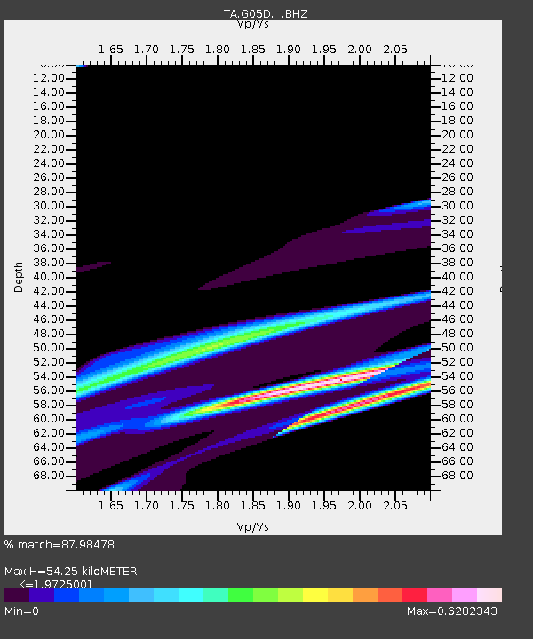
| Estimated Moho Depth: |
54.25 km |
| Estimated Crust Vp/Vs: |
1.97 |
| Assumed Crust Vp: |
6.597 km/s |
| Estimated Crust Vs: |
3.345 km/s |
| Estimated Crust Poisson's Ratio: |
0.33 |
|
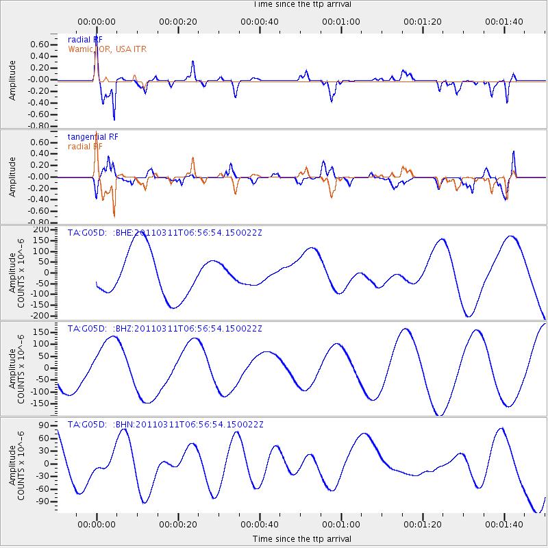
| Radial Match: |
87.98478 % |
| Radial Bump: |
400 |
| Transverse Match: |
55.97312 % |
| Transverse Bump: |
400 |
| SOD ConfigId: |
356183 |
| Insert Time: |
2011-08-10 19:46:54.207 +0000 |
| GWidth: |
2.5 |
| Max Bumps: |
400 |
| Tol: |
0.001 |
|
Signal To Noise
| Channel | StoN | STA | LTA |
| TA:G05D: :BHZ:20110311T06:56:54.150022Z | 1.9719927 | 1.11547066E-4 | 5.656566E-5 |
| TA:G05D: :BHN:20110311T06:56:54.150022Z | 0.36627617 | 1.9429794E-5 | 5.3046842E-5 |
| TA:G05D: :BHE:20110311T06:56:54.150022Z | 0.37567472 | 4.2512984E-5 | 1.13164344E-4 |
| Arrivals |
| Ps | 8.3 SECOND |
| PpPs | 24 SECOND |
| PsPs/PpSs | 32 SECOND |


