You are here: Home > Network List > TA - USArray Transportable Network (new EarthScope stations) Stations List
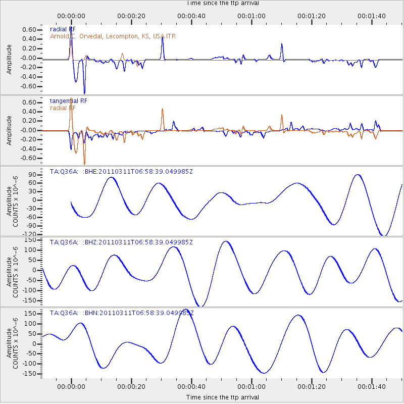
> Station Q36A Arnold C. Orvedal, Lecompton, KS, USA > Earthquake Result Viewer
Q36A Arnold C. Orvedal, Lecompton, KS, USA - Earthquake Result Viewer
| Earthquake location: |
Off East Coast Of Honshu, Japan |
| Earthquake latitude/longitude: |
38.0/143.2 |
| Earthquake time(UTC): |
2011/03/11 (070) 06:46:31 GMT |
| Earthquake Depth: |
31 km |
| Earthquake Magnitude: |
5.9 MB |
| Earthquake Catalog/Contributor: |
WHDF/NEIC |
|
| Network: |
TA USArray Transportable Network (new EarthScope stations) |
| Station: |
Q36A Arnold C. Orvedal, Lecompton, KS, USA |
| Lat/Lon: |
38.96 N/95.46 W |
| Elevation: |
306 m |
|
| Distance: |
86.4 deg |
| Az: |
41.88 deg |
| Baz: |
317.401 deg |
| Ray Param: |
0.044069473 |
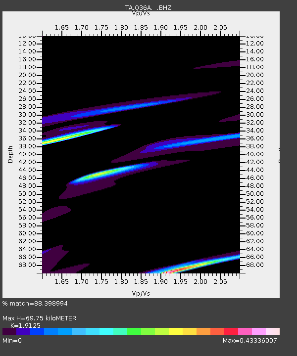
| Estimated Moho Depth: |
69.75 km |
| Estimated Crust Vp/Vs: |
1.91 |
| Assumed Crust Vp: |
6.498 km/s |
| Estimated Crust Vs: |
3.397 km/s |
| Estimated Crust Poisson's Ratio: |
0.31 |
|
| Radial Match: |
88.398994 % |
| Radial Bump: |
400 |
| Transverse Match: |
49.811768 % |
| Transverse Bump: |
400 |
| SOD ConfigId: |
356183 |
| Insert Time: |
2011-08-10 19:53:31.706 +0000 |
| GWidth: |
2.5 |
| Max Bumps: |
400 |
| Tol: |
0.001 |
|
Signal To Noise
| Channel | StoN | STA | LTA |
| TA:Q36A: :BHZ:20110311T06:58:39.049985Z | 0.3773188 | 3.0788604E-5 | 8.159838E-5 |
| TA:Q36A: :BHN:20110311T06:58:39.049985Z | 2.5887947 | 9.889406E-5 | 3.820081E-5 |
| TA:Q36A: :BHE:20110311T06:58:39.049985Z | 0.9913995 | 4.644839E-5 | 4.685133E-5 |
| Arrivals |
| Ps | 10 SECOND |
| PpPs | 31 SECOND |
| PsPs/PpSs | 41 SECOND |


