You are here: Home > Network List > TA - USArray Transportable Network (new EarthScope stations) Stations List
> Station N23A Red Feather Lakes, CO, USA > Earthquake Result Viewer
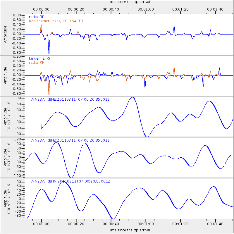
N23A Red Feather Lakes, CO, USA - Earthquake Result Viewer
*The percent match for this event was below the threshold and hence no stack was calculated.
| Earthquake location: |
Off East Coast Of Honshu, Japan |
| Earthquake latitude/longitude: |
38.0/142.7 |
| Earthquake time(UTC): |
2011/03/11 (070) 06:48:45 GMT |
| Earthquake Depth: |
12 km |
| Earthquake Magnitude: |
6.2 MB |
| Earthquake Catalog/Contributor: |
WHDF/NEIC |
|
| Network: |
TA USArray Transportable Network (new EarthScope stations) |
| Station: |
N23A Red Feather Lakes, CO, USA |
| Lat/Lon: |
40.89 N/105.94 W |
| Elevation: |
2458 m |
|
| Distance: |
79.5 deg |
| Az: |
45.896 deg |
| Baz: |
311.521 deg |
| Ray Param: |
$rayparam |
*The percent match for this event was below the threshold and hence was not used in the summary stack. |
|
| Radial Match: |
82.22095 % |
| Radial Bump: |
336 |
| Transverse Match: |
71.35476 % |
| Transverse Bump: |
212 |
| SOD ConfigId: |
356183 |
| Insert Time: |
2011-08-10 21:01:59.961 +0000 |
| GWidth: |
2.5 |
| Max Bumps: |
400 |
| Tol: |
0.001 |
|
Signal To Noise
| Channel | StoN | STA | LTA |
| TA:N23A: :BHZ:20110311T07:00:20.85001Z | 1.3052379 | 2.2378352E-5 | 1.7145037E-5 |
| TA:N23A: :BHN:20110311T07:00:20.85001Z | 1.0415128 | 4.6072346E-5 | 4.4235985E-5 |
| TA:N23A: :BHE:20110311T07:00:20.85001Z | 2.1542225 | 5.6950554E-5 | 2.6436708E-5 |
| Arrivals |
| Ps | |
| PpPs | |
| PsPs/PpSs | |


