You are here: Home > Network List > TA - USArray Transportable Network (new EarthScope stations) Stations List
> Station T30A Plains, KS, USA > Earthquake Result Viewer
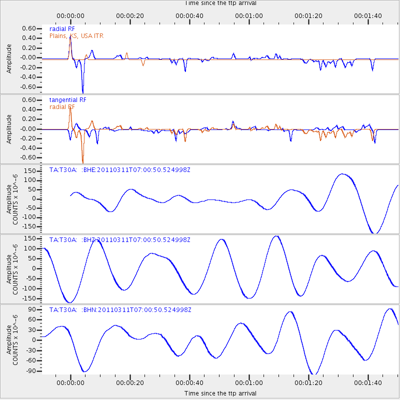
T30A Plains, KS, USA - Earthquake Result Viewer
*The percent match for this event was below the threshold and hence no stack was calculated.
| Earthquake location: |
Off East Coast Of Honshu, Japan |
| Earthquake latitude/longitude: |
38.0/142.7 |
| Earthquake time(UTC): |
2011/03/11 (070) 06:48:45 GMT |
| Earthquake Depth: |
12 km |
| Earthquake Magnitude: |
6.2 MB |
| Earthquake Catalog/Contributor: |
WHDF/NEIC |
|
| Network: |
TA USArray Transportable Network (new EarthScope stations) |
| Station: |
T30A Plains, KS, USA |
| Lat/Lon: |
37.05 N/100.53 W |
| Elevation: |
778 m |
|
| Distance: |
85.2 deg |
| Az: |
45.798 deg |
| Baz: |
314.905 deg |
| Ray Param: |
$rayparam |
*The percent match for this event was below the threshold and hence was not used in the summary stack. |
|
| Radial Match: |
76.29028 % |
| Radial Bump: |
400 |
| Transverse Match: |
50.73732 % |
| Transverse Bump: |
400 |
| SOD ConfigId: |
356183 |
| Insert Time: |
2011-08-10 21:03:29.837 +0000 |
| GWidth: |
2.5 |
| Max Bumps: |
400 |
| Tol: |
0.001 |
|
Signal To Noise
| Channel | StoN | STA | LTA |
| TA:T30A: :BHZ:20110311T07:00:50.524998Z | 2.178359 | 1.3529458E-4 | 6.210849E-5 |
| TA:T30A: :BHN:20110311T07:00:50.524998Z | 0.9658902 | 4.9126527E-5 | 5.0861396E-5 |
| TA:T30A: :BHE:20110311T07:00:50.524998Z | 0.42752486 | 1.570751E-5 | 3.6740577E-5 |
| Arrivals |
| Ps | |
| PpPs | |
| PsPs/PpSs | |


