You are here: Home > Network List > TA - USArray Transportable Network (new EarthScope stations) Stations List
> Station 340A Bronson, TX, USA > Earthquake Result Viewer
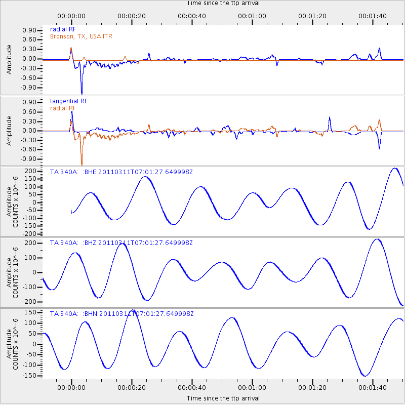
340A Bronson, TX, USA - Earthquake Result Viewer
*The percent match for this event was below the threshold and hence no stack was calculated.
| Earthquake location: |
Off East Coast Of Honshu, Japan |
| Earthquake latitude/longitude: |
38.0/142.7 |
| Earthquake time(UTC): |
2011/03/11 (070) 06:48:45 GMT |
| Earthquake Depth: |
12 km |
| Earthquake Magnitude: |
6.2 MB |
| Earthquake Catalog/Contributor: |
WHDF/NEIC |
|
| Network: |
TA USArray Transportable Network (new EarthScope stations) |
| Station: |
340A Bronson, TX, USA |
| Lat/Lon: |
31.42 N/93.89 W |
| Elevation: |
57 m |
|
| Distance: |
93.1 deg |
| Az: |
45.636 deg |
| Baz: |
318.627 deg |
| Ray Param: |
$rayparam |
*The percent match for this event was below the threshold and hence was not used in the summary stack. |
|
| Radial Match: |
83.83414 % |
| Radial Bump: |
400 |
| Transverse Match: |
62.092834 % |
| Transverse Bump: |
400 |
| SOD ConfigId: |
356183 |
| Insert Time: |
2011-08-10 21:16:12.103 +0000 |
| GWidth: |
2.5 |
| Max Bumps: |
400 |
| Tol: |
0.001 |
|
Signal To Noise
| Channel | StoN | STA | LTA |
| TA:340A: :BHZ:20110311T07:01:27.649998Z | 1.7191311 | 1.2038271E-4 | 7.002532E-5 |
| TA:340A: :BHN:20110311T07:01:27.649998Z | 1.0117316 | 7.463476E-5 | 7.3769326E-5 |
| TA:340A: :BHE:20110311T07:01:27.649998Z | 1.2833138 | 1.0253468E-4 | 7.989837E-5 |
| Arrivals |
| Ps | |
| PpPs | |
| PsPs/PpSs | |


