You are here: Home > Network List > TA - USArray Transportable Network (new EarthScope stations) Stations List
> Station B33A Robert and Kassanda Mosher, Grygla, MN, USA > Earthquake Result Viewer
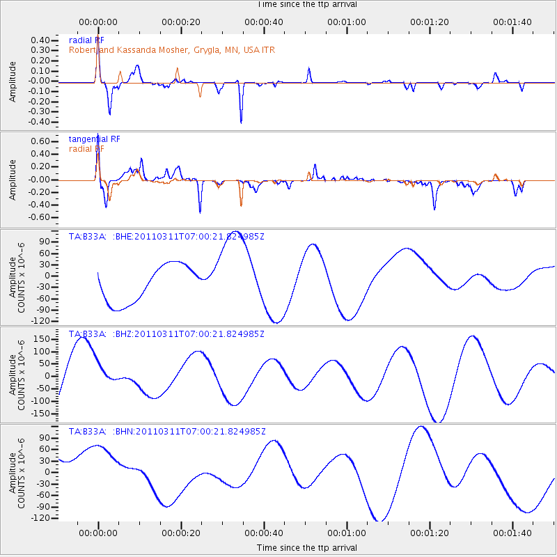
B33A Robert and Kassanda Mosher, Grygla, MN, USA - Earthquake Result Viewer
*The percent match for this event was below the threshold and hence no stack was calculated.
| Earthquake location: |
Off East Coast Of Honshu, Japan |
| Earthquake latitude/longitude: |
38.0/142.7 |
| Earthquake time(UTC): |
2011/03/11 (070) 06:48:45 GMT |
| Earthquake Depth: |
12 km |
| Earthquake Magnitude: |
6.2 MB |
| Earthquake Catalog/Contributor: |
WHDF/NEIC |
|
| Network: |
TA USArray Transportable Network (new EarthScope stations) |
| Station: |
B33A Robert and Kassanda Mosher, Grygla, MN, USA |
| Lat/Lon: |
48.27 N/95.59 W |
| Elevation: |
362 m |
|
| Distance: |
79.7 deg |
| Az: |
35.293 deg |
| Baz: |
316.878 deg |
| Ray Param: |
$rayparam |
*The percent match for this event was below the threshold and hence was not used in the summary stack. |
|
| Radial Match: |
63.69646 % |
| Radial Bump: |
285 |
| Transverse Match: |
40.920864 % |
| Transverse Bump: |
400 |
| SOD ConfigId: |
356183 |
| Insert Time: |
2011-08-10 21:33:26.190 +0000 |
| GWidth: |
2.5 |
| Max Bumps: |
400 |
| Tol: |
0.001 |
|
Signal To Noise
| Channel | StoN | STA | LTA |
| TA:B33A: :BHZ:20110311T07:00:21.824985Z | 0.56898516 | 5.153472E-5 | 9.0573056E-5 |
| TA:B33A: :BHN:20110311T07:00:21.824985Z | 1.6594076 | 7.1486524E-5 | 4.3079544E-5 |
| TA:B33A: :BHE:20110311T07:00:21.824985Z | 2.5026977 | 1.2043437E-4 | 4.812182E-5 |
| Arrivals |
| Ps | |
| PpPs | |
| PsPs/PpSs | |


