You are here: Home > Network List > TA - USArray Transportable Network (new EarthScope stations) Stations List
> Station H25A Fruitdale, SD, USA > Earthquake Result Viewer
H25A Fruitdale, SD, USA - Earthquake Result Viewer
| Earthquake location: |
Off East Coast Of Honshu, Japan |
| Earthquake latitude/longitude: |
37.3/144.2 |
| Earthquake time(UTC): |
2011/03/11 (070) 06:49:16 GMT |
| Earthquake Depth: |
47 km |
| Earthquake Magnitude: |
6.1 MB |
| Earthquake Catalog/Contributor: |
WHDF/NEIC |
|
| Network: |
TA USArray Transportable Network (new EarthScope stations) |
| Station: |
H25A Fruitdale, SD, USA |
| Lat/Lon: |
44.62 N/103.60 W |
| Elevation: |
942 m |
|
| Distance: |
78.0 deg |
| Az: |
42.543 deg |
| Baz: |
311.005 deg |
| Ray Param: |
0.049860656 |
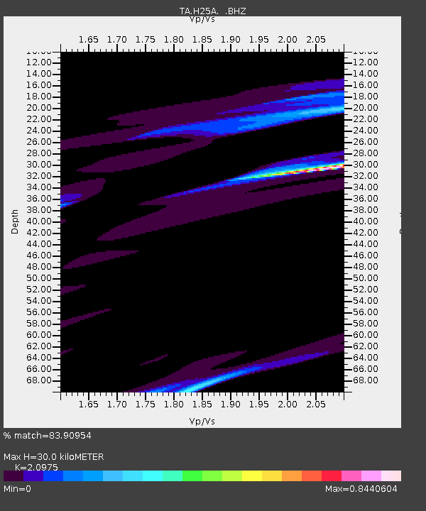
| Estimated Moho Depth: |
30.0 km |
| Estimated Crust Vp/Vs: |
2.10 |
| Assumed Crust Vp: |
6.242 km/s |
| Estimated Crust Vs: |
2.976 km/s |
| Estimated Crust Poisson's Ratio: |
0.35 |
|
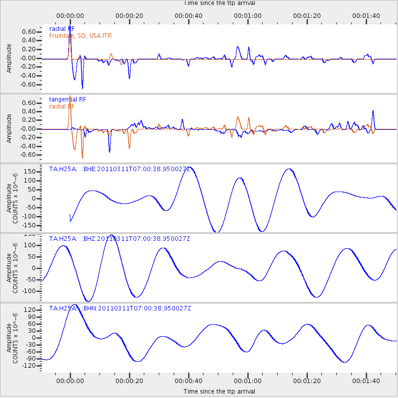
| Radial Match: |
83.90954 % |
| Radial Bump: |
400 |
| Transverse Match: |
59.997547 % |
| Transverse Bump: |
400 |
| SOD ConfigId: |
356183 |
| Insert Time: |
2011-08-10 22:33:23.479 +0000 |
| GWidth: |
2.5 |
| Max Bumps: |
400 |
| Tol: |
0.001 |
|
Signal To Noise
| Channel | StoN | STA | LTA |
| TA:H25A: :BHZ:20110311T07:00:38.950027Z | 1.3503883 | 6.87591E-5 | 5.091802E-5 |
| TA:H25A: :BHN:20110311T07:00:38.950027Z | 3.1640112 | 1.4230229E-4 | 4.497528E-5 |
| TA:H25A: :BHE:20110311T07:00:38.950027Z | 1.1182361 | 4.3061635E-5 | 3.8508537E-5 |
| Arrivals |
| Ps | 5.4 SECOND |
| PpPs | 15 SECOND |
| PsPs/PpSs | 20 SECOND |


