You are here: Home > Network List > TA - USArray Transportable Network (new EarthScope stations) Stations List
> Station X37A Clayton, OK, USA > Earthquake Result Viewer
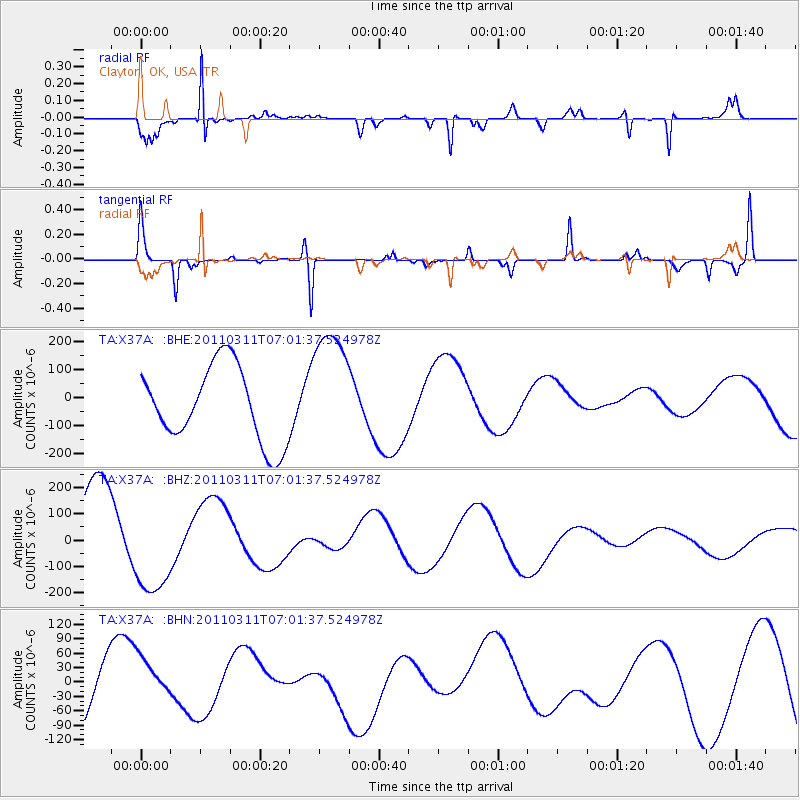
X37A Clayton, OK, USA - Earthquake Result Viewer
*The percent match for this event was below the threshold and hence no stack was calculated.
| Earthquake location: |
Off East Coast Of Honshu, Japan |
| Earthquake latitude/longitude: |
37.3/144.2 |
| Earthquake time(UTC): |
2011/03/11 (070) 06:49:16 GMT |
| Earthquake Depth: |
47 km |
| Earthquake Magnitude: |
6.1 MB |
| Earthquake Catalog/Contributor: |
WHDF/NEIC |
|
| Network: |
TA USArray Transportable Network (new EarthScope stations) |
| Station: |
X37A Clayton, OK, USA |
| Lat/Lon: |
34.59 N/95.37 W |
| Elevation: |
207 m |
|
| Distance: |
89.5 deg |
| Az: |
45.372 deg |
| Baz: |
316.564 deg |
| Ray Param: |
$rayparam |
*The percent match for this event was below the threshold and hence was not used in the summary stack. |
|
| Radial Match: |
78.60637 % |
| Radial Bump: |
211 |
| Transverse Match: |
80.53586 % |
| Transverse Bump: |
103 |
| SOD ConfigId: |
356183 |
| Insert Time: |
2011-08-10 22:43:14.703 +0000 |
| GWidth: |
2.5 |
| Max Bumps: |
400 |
| Tol: |
0.001 |
|
Signal To Noise
| Channel | StoN | STA | LTA |
| TA:X37A: :BHZ:20110311T07:01:37.524978Z | 1.1377237 | 1.891702E-4 | 1.6627077E-4 |
| TA:X37A: :BHN:20110311T07:01:37.524978Z | 1.1297354 | 4.9793907E-5 | 4.407573E-5 |
| TA:X37A: :BHE:20110311T07:01:37.524978Z | 1.6612036 | 2.2265024E-4 | 1.3402947E-4 |
| Arrivals |
| Ps | |
| PpPs | |
| PsPs/PpSs | |


