You are here: Home > Network List > TA - USArray Transportable Network (new EarthScope stations) Stations List
> Station Q35A Mercer Eighty, Eskridge, KS, USA > Earthquake Result Viewer
Q35A Mercer Eighty, Eskridge, KS, USA - Earthquake Result Viewer
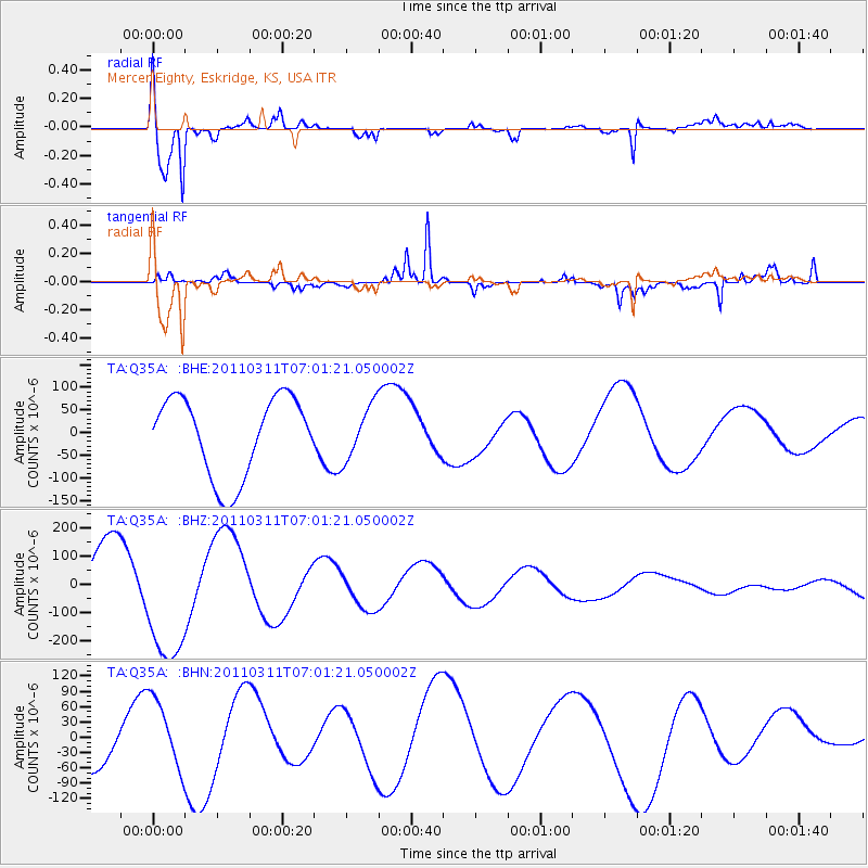
| Earthquake location: |
Off East Coast Of Honshu, Japan |
| Earthquake latitude/longitude: |
37.3/144.2 |
| Earthquake time(UTC): |
2011/03/11 (070) 06:49:16 GMT |
| Earthquake Depth: |
47 km |
| Earthquake Magnitude: |
6.1 MB |
| Earthquake Catalog/Contributor: |
WHDF/NEIC |
|
| Network: |
TA USArray Transportable Network (new EarthScope stations) |
| Station: |
Q35A Mercer Eighty, Eskridge, KS, USA |
| Lat/Lon: |
38.86 N/96.04 W |
| Elevation: |
402 m |
|
| Distance: |
86.1 deg |
| Az: |
42.814 deg |
| Baz: |
316.069 deg |
| Ray Param: |
0.044247214 |
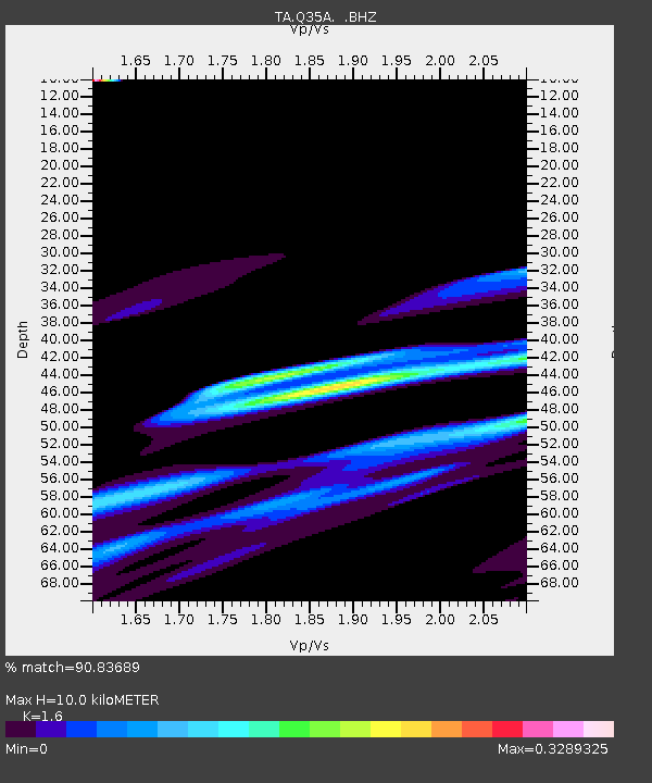
| Estimated Moho Depth: |
10.0 km |
| Estimated Crust Vp/Vs: |
1.60 |
| Assumed Crust Vp: |
6.483 km/s |
| Estimated Crust Vs: |
4.052 km/s |
| Estimated Crust Poisson's Ratio: |
0.18 |
|
| Radial Match: |
90.83689 % |
| Radial Bump: |
378 |
| Transverse Match: |
77.106026 % |
| Transverse Bump: |
227 |
| SOD ConfigId: |
356183 |
| Insert Time: |
2011-08-10 22:44:07.712 +0000 |
| GWidth: |
2.5 |
| Max Bumps: |
400 |
| Tol: |
0.001 |
|
Signal To Noise
| Channel | StoN | STA | LTA |
| TA:Q35A: :BHZ:20110311T07:01:21.050002Z | 2.0128293 | 2.3403397E-4 | 1.16271156E-4 |
| TA:Q35A: :BHN:20110311T07:01:21.050002Z | 1.4441007 | 6.9767935E-5 | 4.8312373E-5 |
| TA:Q35A: :BHE:20110311T07:01:21.050002Z | 0.6711165 | 5.91204E-5 | 8.8092616E-5 |
| Arrivals |
| Ps | 1.0 SECOND |
| PpPs | 3.9 SECOND |
| PsPs/PpSs | 4.9 SECOND |


