You are here: Home > Network List > TA - USArray Transportable Network (new EarthScope stations) Stations List
> Station K36A Gilmore City, IA, USA > Earthquake Result Viewer
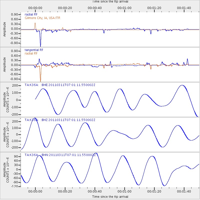
K36A Gilmore City, IA, USA - Earthquake Result Viewer
*The percent match for this event was below the threshold and hence no stack was calculated.
| Earthquake location: |
Off East Coast Of Honshu, Japan |
| Earthquake latitude/longitude: |
37.3/144.2 |
| Earthquake time(UTC): |
2011/03/11 (070) 06:49:16 GMT |
| Earthquake Depth: |
47 km |
| Earthquake Magnitude: |
6.1 MB |
| Earthquake Catalog/Contributor: |
WHDF/NEIC |
|
| Network: |
TA USArray Transportable Network (new EarthScope stations) |
| Station: |
K36A Gilmore City, IA, USA |
| Lat/Lon: |
42.64 N/94.45 W |
| Elevation: |
364 m |
|
| Distance: |
84.1 deg |
| Az: |
39.326 deg |
| Baz: |
316.803 deg |
| Ray Param: |
$rayparam |
*The percent match for this event was below the threshold and hence was not used in the summary stack. |
|
| Radial Match: |
85.979744 % |
| Radial Bump: |
370 |
| Transverse Match: |
70.23186 % |
| Transverse Bump: |
400 |
| SOD ConfigId: |
356183 |
| Insert Time: |
2011-08-10 22:52:54.182 +0000 |
| GWidth: |
2.5 |
| Max Bumps: |
400 |
| Tol: |
0.001 |
|
Signal To Noise
| Channel | StoN | STA | LTA |
| TA:K36A: :BHZ:20110311T07:01:11.550002Z | 1.7706283 | 2.0700549E-4 | 1.16910756E-4 |
| TA:K36A: :BHN:20110311T07:01:11.550002Z | 1.4024142 | 8.638306E-5 | 6.1595965E-5 |
| TA:K36A: :BHE:20110311T07:01:11.550002Z | 0.6222013 | 7.4945376E-5 | 1.2045197E-4 |
| Arrivals |
| Ps | |
| PpPs | |
| PsPs/PpSs | |


