You are here: Home > Network List > TA - USArray Transportable Network (new EarthScope stations) Stations List
> Station H26A Fairpoint, SD, USA > Earthquake Result Viewer
H26A Fairpoint, SD, USA - Earthquake Result Viewer
| Earthquake location: |
Off East Coast Of Honshu, Japan |
| Earthquake latitude/longitude: |
37.6/142.9 |
| Earthquake time(UTC): |
2011/03/11 (070) 06:55:33 GMT |
| Earthquake Depth: |
40 km |
| Earthquake Magnitude: |
5.9 MB |
| Earthquake Catalog/Contributor: |
WHDF/NEIC |
|
| Network: |
TA USArray Transportable Network (new EarthScope stations) |
| Station: |
H26A Fairpoint, SD, USA |
| Lat/Lon: |
44.62 N/102.77 W |
| Elevation: |
879 m |
|
| Distance: |
79.0 deg |
| Az: |
41.506 deg |
| Baz: |
312.49 deg |
| Ray Param: |
0.049194794 |
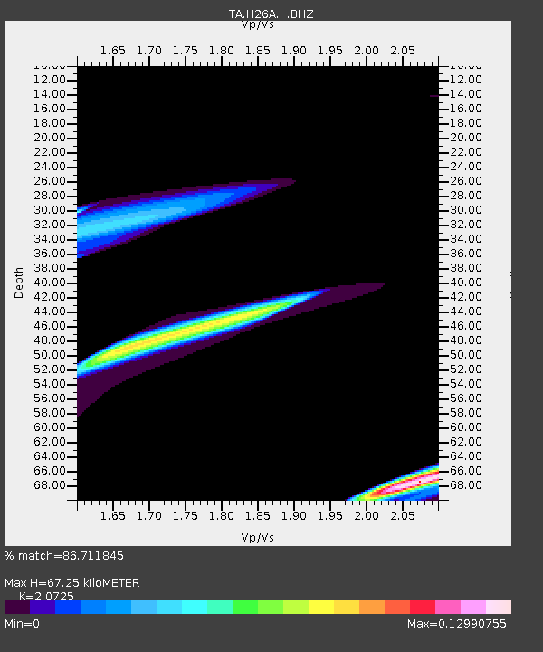
| Estimated Moho Depth: |
67.25 km |
| Estimated Crust Vp/Vs: |
2.07 |
| Assumed Crust Vp: |
6.242 km/s |
| Estimated Crust Vs: |
3.012 km/s |
| Estimated Crust Poisson's Ratio: |
0.35 |
|
| Radial Match: |
86.711845 % |
| Radial Bump: |
400 |
| Transverse Match: |
63.264908 % |
| Transverse Bump: |
356 |
| SOD ConfigId: |
356183 |
| Insert Time: |
2011-08-11 02:29:53.955 +0000 |
| GWidth: |
2.5 |
| Max Bumps: |
400 |
| Tol: |
0.001 |
|

Signal To Noise
| Channel | StoN | STA | LTA |
| TA:H26A: :BHZ:20110311T07:07:02.350Z | 0.63064206 | 3.908746E-5 | 6.198042E-5 |
| TA:H26A: :BHN:20110311T07:07:02.350Z | 1.6115718 | 1.2425892E-4 | 7.7104174E-5 |
| TA:H26A: :BHE:20110311T07:07:02.350Z | 0.78385425 | 4.9440267E-5 | 6.307329E-5 |
| Arrivals |
| Ps | 12 SECOND |
| PpPs | 32 SECOND |
| PsPs/PpSs | 44 SECOND |


