You are here: Home > Network List > TA - USArray Transportable Network (new EarthScope stations) Stations List
> Station U34A Anderson Ranch, Garber, OK, USA > Earthquake Result Viewer
U34A Anderson Ranch, Garber, OK, USA - Earthquake Result Viewer
| Earthquake location: |
Off East Coast Of Honshu, Japan |
| Earthquake latitude/longitude: |
37.6/142.9 |
| Earthquake time(UTC): |
2011/03/11 (070) 06:55:33 GMT |
| Earthquake Depth: |
40 km |
| Earthquake Magnitude: |
5.9 MB |
| Earthquake Catalog/Contributor: |
WHDF/NEIC |
|
| Network: |
TA USArray Transportable Network (new EarthScope stations) |
| Station: |
U34A Anderson Ranch, Garber, OK, USA |
| Lat/Lon: |
36.44 N/97.54 W |
| Elevation: |
345 m |
|
| Distance: |
87.6 deg |
| Az: |
44.567 deg |
| Baz: |
316.25 deg |
| Ray Param: |
0.043170717 |
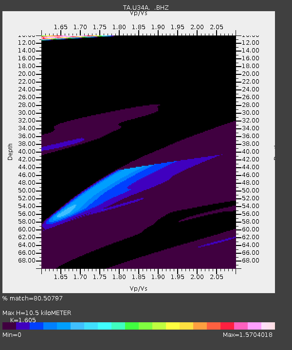
| Estimated Moho Depth: |
10.5 km |
| Estimated Crust Vp/Vs: |
1.61 |
| Assumed Crust Vp: |
6.483 km/s |
| Estimated Crust Vs: |
4.039 km/s |
| Estimated Crust Poisson's Ratio: |
0.18 |
|
| Radial Match: |
80.50797 % |
| Radial Bump: |
400 |
| Transverse Match: |
56.16854 % |
| Transverse Bump: |
400 |
| SOD ConfigId: |
356183 |
| Insert Time: |
2011-08-11 02:37:30.590 +0000 |
| GWidth: |
2.5 |
| Max Bumps: |
400 |
| Tol: |
0.001 |
|
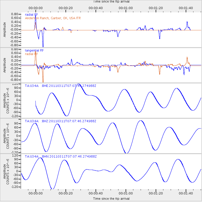
Signal To Noise
| Channel | StoN | STA | LTA |
| TA:U34A: :BHZ:20110311T07:07:46.274988Z | 2.3267775 | 6.753524E-5 | 2.9025228E-5 |
| TA:U34A: :BHN:20110311T07:07:46.274988Z | 1.648865 | 1.0340297E-4 | 6.27116E-5 |
| TA:U34A: :BHE:20110311T07:07:46.274988Z | 2.1388159 | 1.19489196E-4 | 5.586699E-5 |
| Arrivals |
| Ps | 1.0 SECOND |
| PpPs | 4.1 SECOND |
| PsPs/PpSs | 5.1 SECOND |


