You are here: Home > Network List > TA - USArray Transportable Network (new EarthScope stations) Stations List
> Station P34A Walnut Farm, Randolph, KS, USA > Earthquake Result Viewer
P34A Walnut Farm, Randolph, KS, USA - Earthquake Result Viewer
| Earthquake location: |
Off East Coast Of Honshu, Japan |
| Earthquake latitude/longitude: |
37.6/142.9 |
| Earthquake time(UTC): |
2011/03/11 (070) 06:55:33 GMT |
| Earthquake Depth: |
40 km |
| Earthquake Magnitude: |
5.9 MB |
| Earthquake Catalog/Contributor: |
WHDF/NEIC |
|
| Network: |
TA USArray Transportable Network (new EarthScope stations) |
| Station: |
P34A Walnut Farm, Randolph, KS, USA |
| Lat/Lon: |
39.55 N/96.83 W |
| Elevation: |
429 m |
|
| Distance: |
85.7 deg |
| Az: |
42.015 deg |
| Baz: |
316.535 deg |
| Ray Param: |
0.044510316 |
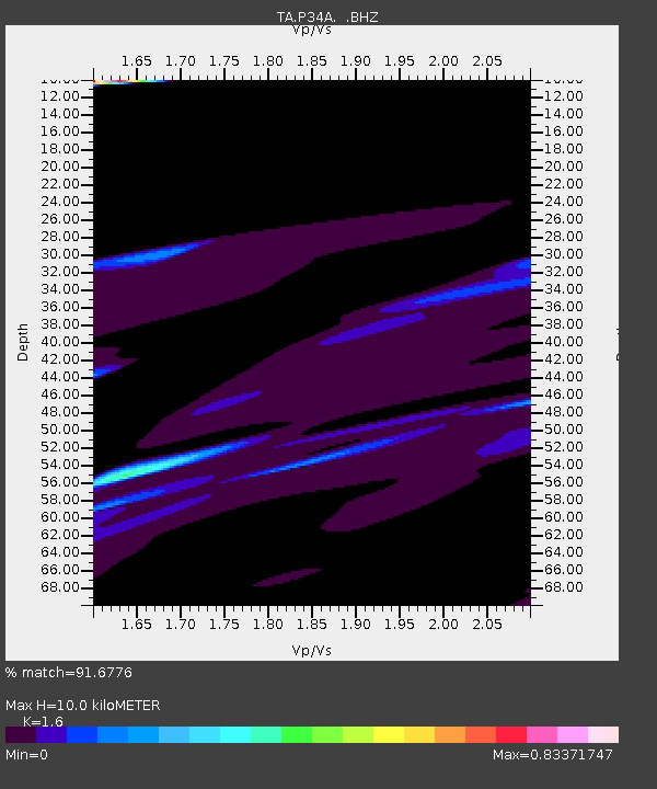
| Estimated Moho Depth: |
10.0 km |
| Estimated Crust Vp/Vs: |
1.60 |
| Assumed Crust Vp: |
6.483 km/s |
| Estimated Crust Vs: |
4.052 km/s |
| Estimated Crust Poisson's Ratio: |
0.18 |
|
| Radial Match: |
91.6776 % |
| Radial Bump: |
326 |
| Transverse Match: |
50.129295 % |
| Transverse Bump: |
400 |
| SOD ConfigId: |
356183 |
| Insert Time: |
2011-08-11 02:50:40.336 +0000 |
| GWidth: |
2.5 |
| Max Bumps: |
400 |
| Tol: |
0.001 |
|

Signal To Noise
| Channel | StoN | STA | LTA |
| TA:P34A: :BHZ:20110311T07:07:37.199976Z | 1.0888603 | 9.437499E-5 | 8.6673186E-5 |
| TA:P34A: :BHN:20110311T07:07:37.199976Z | 0.5074066 | 2.4637257E-5 | 4.855526E-5 |
| TA:P34A: :BHE:20110311T07:07:37.199976Z | 1.4781342 | 1.03653896E-4 | 7.012482E-5 |
| Arrivals |
| Ps | 1.0 SECOND |
| PpPs | 3.9 SECOND |
| PsPs/PpSs | 4.9 SECOND |


