You are here: Home > Network List > US - United States National Seismic Network Stations List
> Station MNTX Cornudas Mountains, Texas, USA > Earthquake Result Viewer
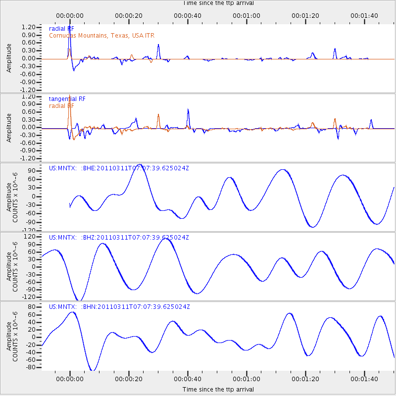
MNTX Cornudas Mountains, Texas, USA - Earthquake Result Viewer
*The percent match for this event was below the threshold and hence no stack was calculated.
| Earthquake location: |
Off East Coast Of Honshu, Japan |
| Earthquake latitude/longitude: |
37.6/142.9 |
| Earthquake time(UTC): |
2011/03/11 (070) 06:55:33 GMT |
| Earthquake Depth: |
40 km |
| Earthquake Magnitude: |
5.9 MB |
| Earthquake Catalog/Contributor: |
WHDF/NEIC |
|
| Network: |
US United States National Seismic Network |
| Station: |
MNTX Cornudas Mountains, Texas, USA |
| Lat/Lon: |
31.70 N/105.38 W |
| Elevation: |
404 m |
|
| Distance: |
86.2 deg |
| Az: |
52.503 deg |
| Baz: |
312.298 deg |
| Ray Param: |
$rayparam |
*The percent match for this event was below the threshold and hence was not used in the summary stack. |
|
| Radial Match: |
68.6307 % |
| Radial Bump: |
400 |
| Transverse Match: |
82.63714 % |
| Transverse Bump: |
311 |
| SOD ConfigId: |
356183 |
| Insert Time: |
2011-08-11 03:12:28.663 +0000 |
| GWidth: |
2.5 |
| Max Bumps: |
400 |
| Tol: |
0.001 |
|
Signal To Noise
| Channel | StoN | STA | LTA |
| US:MNTX: :BHZ:20110311T07:07:39.625024Z | 2.9870658 | 1.1170401E-4 | 3.7395897E-5 |
| US:MNTX: :BHN:20110311T07:07:39.625024Z | 1.2463359 | 6.493899E-5 | 5.210393E-5 |
| US:MNTX: :BHE:20110311T07:07:39.625024Z | 1.1818235 | 5.4879696E-5 | 4.643646E-5 |
| Arrivals |
| Ps | |
| PpPs | |
| PsPs/PpSs | |


