You are here: Home > Network List > G - GEOSCOPE Stations List
> Station PPTF Pamatai - Papeete - Tahiti island - French Polynesia, France > Earthquake Result Viewer
PPTF Pamatai - Papeete - Tahiti island - French Polynesia, France - Earthquake Result Viewer

| Earthquake location: |
Near East Coast Of Honshu, Japan |
| Earthquake latitude/longitude: |
35.7/140.9 |
| Earthquake time(UTC): |
2011/03/11 (070) 06:57:16 GMT |
| Earthquake Depth: |
48 km |
| Earthquake Magnitude: |
6.0 MB |
| Earthquake Catalog/Contributor: |
WHDF/NEIC |
|
| Network: |
G GEOSCOPE |
| Station: |
PPTF Pamatai - Papeete - Tahiti island - French Polynesia, France |
| Lat/Lon: |
17.59 S/149.57 W |
| Elevation: |
705 m |
|
| Distance: |
84.5 deg |
| Az: |
116.108 deg |
| Baz: |
309.99 deg |
| Ray Param: |
0.045387268 |
| Estimated Moho Depth: |
53.5 km |
| Estimated Crust Vp/Vs: |
1.78 |
| Assumed Crust Vp: |
4.24 km/s |
| Estimated Crust Vs: |
2.379 km/s |
| Estimated Crust Poisson's Ratio: |
0.27 |
|
| Radial Match: |
81.00089 % |
| Radial Bump: |
400 |
| Transverse Match: |
66.230095 % |
| Transverse Bump: |
400 |
| SOD ConfigId: |
356183 |
| Insert Time: |
2011-08-11 03:48:17.064 +0000 |
| GWidth: |
2.5 |
| Max Bumps: |
400 |
| Tol: |
0.001 |
|
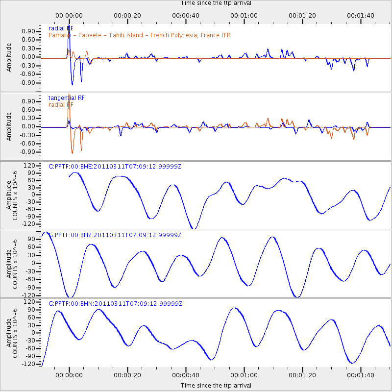
Signal To Noise
| Channel | StoN | STA | LTA |
| G:PPTF:00:BHZ:20110311T07:09:12.99999Z | 1.3439828 | 1.2520238E-4 | 9.315772E-5 |
| G:PPTF:00:BHN:20110311T07:09:12.99999Z | 0.506244 | 4.659943E-5 | 9.204935E-5 |
| G:PPTF:00:BHE:20110311T07:09:12.99999Z | 1.5518076 | 7.750868E-5 | 4.994735E-5 |
| Arrivals |
| Ps | 10.0 SECOND |
| PpPs | 35 SECOND |
| PsPs/PpSs | 45 SECOND |


