You are here: Home > Network List > MN - MEDNET Project Stations List
> Station TIR Tirana, Albania > Earthquake Result Viewer
TIR Tirana, Albania - Earthquake Result Viewer
| Earthquake location: |
Near East Coast Of Honshu, Japan |
| Earthquake latitude/longitude: |
35.7/140.9 |
| Earthquake time(UTC): |
2011/03/11 (070) 06:57:16 GMT |
| Earthquake Depth: |
48 km |
| Earthquake Magnitude: |
6.0 MB |
| Earthquake Catalog/Contributor: |
WHDF/NEIC |
|
| Network: |
MN MEDNET Project |
| Station: |
TIR Tirana, Albania |
| Lat/Lon: |
41.35 N/19.86 E |
| Elevation: |
247 m |
|
| Distance: |
86.2 deg |
| Az: |
319.704 deg |
| Baz: |
44.351 deg |
| Ray Param: |
0.044164002 |
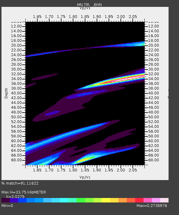
| Estimated Moho Depth: |
33.75 km |
| Estimated Crust Vp/Vs: |
2.03 |
| Assumed Crust Vp: |
5.967 km/s |
| Estimated Crust Vs: |
2.943 km/s |
| Estimated Crust Poisson's Ratio: |
0.34 |
|
| Radial Match: |
91.11622 % |
| Radial Bump: |
400 |
| Transverse Match: |
46.74754 % |
| Transverse Bump: |
362 |
| SOD ConfigId: |
356183 |
| Insert Time: |
2011-08-11 03:57:39.087 +0000 |
| GWidth: |
2.5 |
| Max Bumps: |
400 |
| Tol: |
0.001 |
|
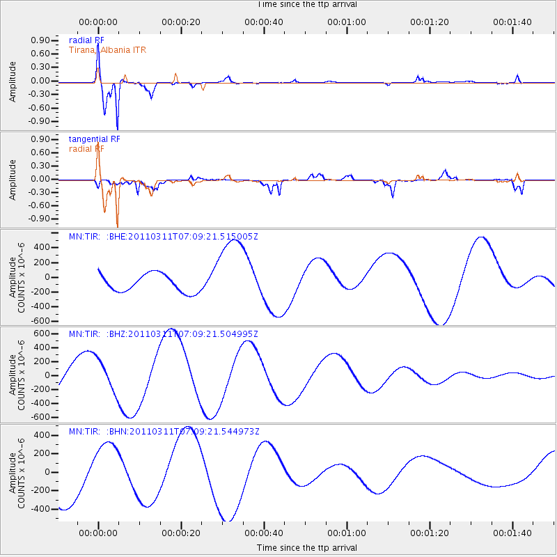
Signal To Noise
| Channel | StoN | STA | LTA |
| MN:TIR: :BHZ:20110311T07:09:21.504995Z | 1.0483898 | 2.2538507E-4 | 2.1498212E-4 |
| MN:TIR: :BHN:20110311T07:09:21.544973Z | 1.1022911 | 3.4510947E-4 | 3.130838E-4 |
| MN:TIR: :BHE:20110311T07:09:21.515005Z | 4.420675 | 5.2614213E-4 | 1.19018514E-4 |
| Arrivals |
| Ps | 5.9 SECOND |
| PpPs | 17 SECOND |
| PsPs/PpSs | 23 SECOND |


