You are here: Home > Network List > TA - USArray Transportable Network (new EarthScope stations) Stations List
> Station I29A Vivian, Onida, SD, USA > Earthquake Result Viewer
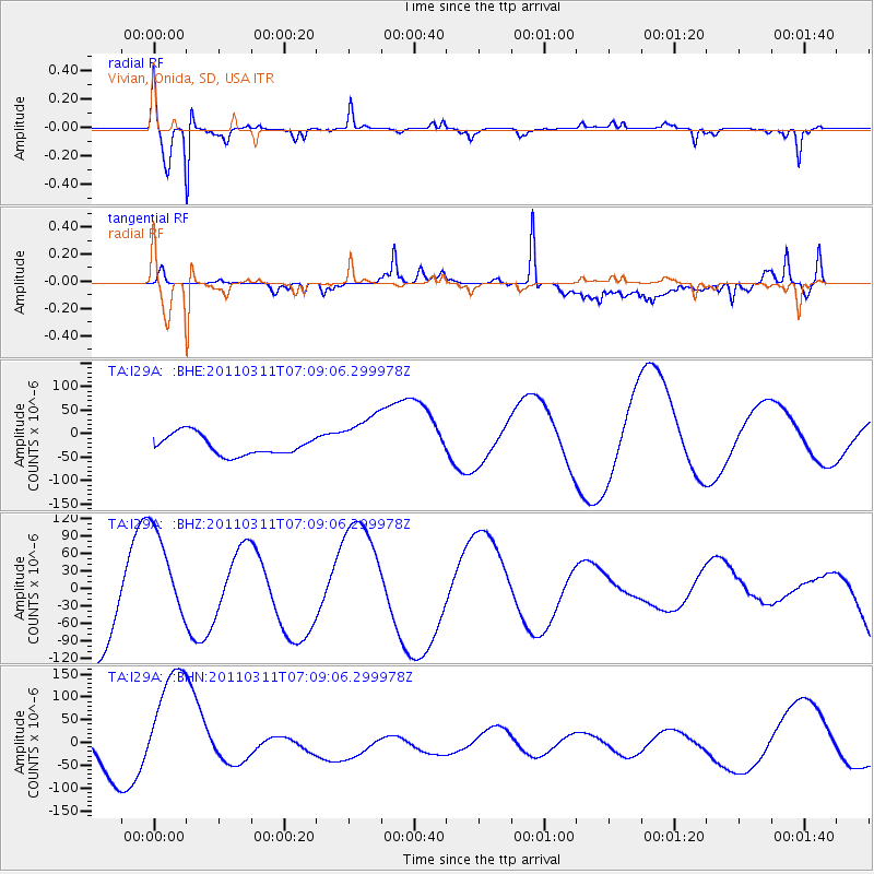
I29A Vivian, Onida, SD, USA - Earthquake Result Viewer

| Earthquake location: |
Near East Coast Of Honshu, Japan |
| Earthquake latitude/longitude: |
35.7/140.9 |
| Earthquake time(UTC): |
2011/03/11 (070) 06:57:16 GMT |
| Earthquake Depth: |
48 km |
| Earthquake Magnitude: |
6.0 MB |
| Earthquake Catalog/Contributor: |
WHDF/NEIC |
|
| Network: |
TA USArray Transportable Network (new EarthScope stations) |
| Station: |
I29A Vivian, Onida, SD, USA |
| Lat/Lon: |
44.02 N/100.30 W |
| Elevation: |
592 m |
|
| Distance: |
83.1 deg |
| Az: |
39.539 deg |
| Baz: |
314.099 deg |
| Ray Param: |
0.046318196 |
| Estimated Moho Depth: |
10.75 km |
| Estimated Crust Vp/Vs: |
1.62 |
| Assumed Crust Vp: |
6.53 km/s |
| Estimated Crust Vs: |
4.037 km/s |
| Estimated Crust Poisson's Ratio: |
0.19 |
|
| Radial Match: |
81.35622 % |
| Radial Bump: |
316 |
| Transverse Match: |
53.7257 % |
| Transverse Bump: |
375 |
| SOD ConfigId: |
356183 |
| Insert Time: |
2011-08-11 04:15:54.128 +0000 |
| GWidth: |
2.5 |
| Max Bumps: |
400 |
| Tol: |
0.001 |
|
Signal To Noise
| Channel | StoN | STA | LTA |
| TA:I29A: :BHZ:20110311T07:09:06.299978Z | 1.0605156 | 8.769213E-5 | 8.26882E-5 |
| TA:I29A: :BHN:20110311T07:09:06.299978Z | 5.565942 | 1.4313059E-4 | 2.571543E-5 |
| TA:I29A: :BHE:20110311T07:09:06.299978Z | 2.4569557 | 5.2613395E-5 | 2.141406E-5 |
| Arrivals |
| Ps | 1.0 SECOND |
| PpPs | 4.2 SECOND |
| PsPs/PpSs | 5.2 SECOND |


