You are here: Home > Network List > TA - USArray Transportable Network (new EarthScope stations) Stations List
> Station H31A Wolsey, SD, USA > Earthquake Result Viewer
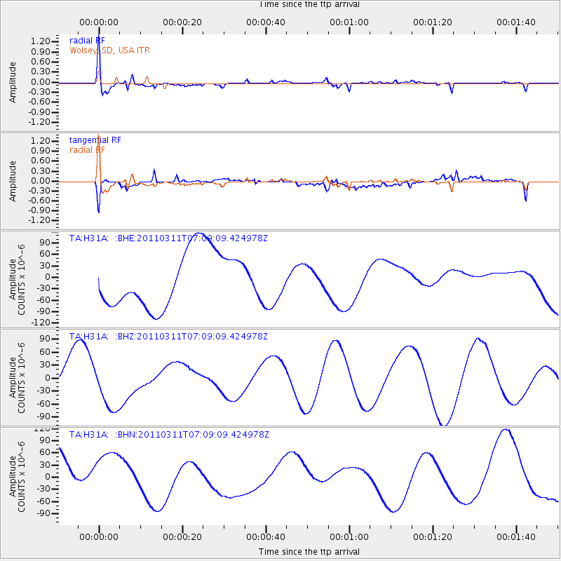
H31A Wolsey, SD, USA - Earthquake Result Viewer
*The percent match for this event was below the threshold and hence no stack was calculated.
| Earthquake location: |
Near East Coast Of Honshu, Japan |
| Earthquake latitude/longitude: |
35.7/140.9 |
| Earthquake time(UTC): |
2011/03/11 (070) 06:57:16 GMT |
| Earthquake Depth: |
48 km |
| Earthquake Magnitude: |
6.0 MB |
| Earthquake Catalog/Contributor: |
WHDF/NEIC |
|
| Network: |
TA USArray Transportable Network (new EarthScope stations) |
| Station: |
H31A Wolsey, SD, USA |
| Lat/Lon: |
44.48 N/98.48 W |
| Elevation: |
415 m |
|
| Distance: |
83.8 deg |
| Az: |
38.282 deg |
| Baz: |
315.225 deg |
| Ray Param: |
$rayparam |
*The percent match for this event was below the threshold and hence was not used in the summary stack. |
|
| Radial Match: |
66.88533 % |
| Radial Bump: |
400 |
| Transverse Match: |
59.056026 % |
| Transverse Bump: |
400 |
| SOD ConfigId: |
356183 |
| Insert Time: |
2011-08-11 04:30:05.678 +0000 |
| GWidth: |
2.5 |
| Max Bumps: |
400 |
| Tol: |
0.001 |
|
Signal To Noise
| Channel | StoN | STA | LTA |
| TA:H31A: :BHZ:20110311T07:09:09.424978Z | 1.3873193 | 6.133113E-5 | 4.420837E-5 |
| TA:H31A: :BHN:20110311T07:09:09.424978Z | 1.1895677 | 6.52545E-5 | 5.485564E-5 |
| TA:H31A: :BHE:20110311T07:09:09.424978Z | 1.0959721 | 7.617402E-5 | 6.9503614E-5 |
| Arrivals |
| Ps | |
| PpPs | |
| PsPs/PpSs | |


