You are here: Home > Network List > US - United States National Seismic Network Stations List
> Station MNTX Cornudas Mountains, Texas, USA > Earthquake Result Viewer
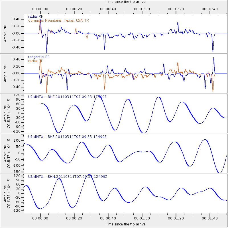
MNTX Cornudas Mountains, Texas, USA - Earthquake Result Viewer
*The percent match for this event was below the threshold and hence no stack was calculated.
| Earthquake location: |
Near East Coast Of Honshu, Japan |
| Earthquake latitude/longitude: |
35.7/140.9 |
| Earthquake time(UTC): |
2011/03/11 (070) 06:57:16 GMT |
| Earthquake Depth: |
48 km |
| Earthquake Magnitude: |
6.0 MB |
| Earthquake Catalog/Contributor: |
WHDF/NEIC |
|
| Network: |
US United States National Seismic Network |
| Station: |
MNTX Cornudas Mountains, Texas, USA |
| Lat/Lon: |
31.70 N/105.38 W |
| Elevation: |
404 m |
|
| Distance: |
88.6 deg |
| Az: |
51.305 deg |
| Baz: |
311.827 deg |
| Ray Param: |
$rayparam |
*The percent match for this event was below the threshold and hence was not used in the summary stack. |
|
| Radial Match: |
72.41715 % |
| Radial Bump: |
400 |
| Transverse Match: |
84.414925 % |
| Transverse Bump: |
400 |
| SOD ConfigId: |
356183 |
| Insert Time: |
2011-08-11 04:45:07.347 +0000 |
| GWidth: |
2.5 |
| Max Bumps: |
400 |
| Tol: |
0.001 |
|
Signal To Noise
| Channel | StoN | STA | LTA |
| US:MNTX: :BHZ:20110311T07:09:33.12499Z | 0.87171686 | 4.94662E-5 | 5.6745725E-5 |
| US:MNTX: :BHN:20110311T07:09:33.12499Z | 3.1911342 | 1.1327552E-4 | 3.5496945E-5 |
| US:MNTX: :BHE:20110311T07:09:33.12499Z | 1.3492848 | 8.702715E-5 | 6.449872E-5 |
| Arrivals |
| Ps | |
| PpPs | |
| PsPs/PpSs | |


