You are here: Home > Network List > TA - USArray Transportable Network (new EarthScope stations) Stations List
> Station 334A Lometa, TX, USA > Earthquake Result Viewer
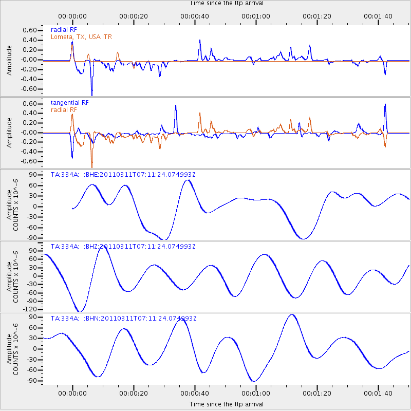
334A Lometa, TX, USA - Earthquake Result Viewer
*The percent match for this event was below the threshold and hence no stack was calculated.
| Earthquake location: |
Off East Coast Of Honshu, Japan |
| Earthquake latitude/longitude: |
37.4/144.7 |
| Earthquake time(UTC): |
2011/03/11 (070) 06:59:00 GMT |
| Earthquake Depth: |
36 km |
| Earthquake Magnitude: |
6.3 MB |
| Earthquake Catalog/Contributor: |
WHDF/NEIC |
|
| Network: |
TA USArray Transportable Network (new EarthScope stations) |
| Station: |
334A Lometa, TX, USA |
| Lat/Lon: |
31.33 N/98.24 W |
| Elevation: |
389 m |
|
| Distance: |
89.8 deg |
| Az: |
49.658 deg |
| Baz: |
314.786 deg |
| Ray Param: |
$rayparam |
*The percent match for this event was below the threshold and hence was not used in the summary stack. |
|
| Radial Match: |
68.92541 % |
| Radial Bump: |
400 |
| Transverse Match: |
61.14016 % |
| Transverse Bump: |
400 |
| SOD ConfigId: |
356183 |
| Insert Time: |
2011-08-11 05:53:17.743 +0000 |
| GWidth: |
2.5 |
| Max Bumps: |
400 |
| Tol: |
0.001 |
|
Signal To Noise
| Channel | StoN | STA | LTA |
| TA:334A: :BHZ:20110311T07:11:24.074993Z | 2.779265 | 1.16785355E-4 | 4.202023E-5 |
| TA:334A: :BHN:20110311T07:11:24.074993Z | 0.558371 | 2.1039205E-5 | 3.7679616E-5 |
| TA:334A: :BHE:20110311T07:11:24.074993Z | 2.4896178 | 8.992975E-5 | 3.612191E-5 |
| Arrivals |
| Ps | |
| PpPs | |
| PsPs/PpSs | |


