You are here: Home > Network List > TA - USArray Transportable Network (new EarthScope stations) Stations List
> Station L32A Elgin, NE, USA > Earthquake Result Viewer
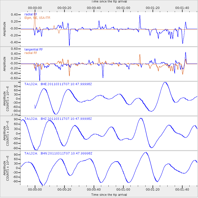
L32A Elgin, NE, USA - Earthquake Result Viewer
*The percent match for this event was below the threshold and hence no stack was calculated.
| Earthquake location: |
Off East Coast Of Honshu, Japan |
| Earthquake latitude/longitude: |
37.4/144.7 |
| Earthquake time(UTC): |
2011/03/11 (070) 06:59:00 GMT |
| Earthquake Depth: |
36 km |
| Earthquake Magnitude: |
6.3 MB |
| Earthquake Catalog/Contributor: |
WHDF/NEIC |
|
| Network: |
TA USArray Transportable Network (new EarthScope stations) |
| Station: |
L32A Elgin, NE, USA |
| Lat/Lon: |
42.00 N/98.01 W |
| Elevation: |
586 m |
|
| Distance: |
82.5 deg |
| Az: |
41.931 deg |
| Baz: |
314.404 deg |
| Ray Param: |
$rayparam |
*The percent match for this event was below the threshold and hence was not used in the summary stack. |
|
| Radial Match: |
63.843426 % |
| Radial Bump: |
324 |
| Transverse Match: |
64.54952 % |
| Transverse Bump: |
342 |
| SOD ConfigId: |
356183 |
| Insert Time: |
2011-08-11 06:00:48.482 +0000 |
| GWidth: |
2.5 |
| Max Bumps: |
400 |
| Tol: |
0.001 |
|
Signal To Noise
| Channel | StoN | STA | LTA |
| TA:L32A: :BHZ:20110311T07:10:47.99998Z | 1.5968393 | 9.056436E-5 | 5.671476E-5 |
| TA:L32A: :BHN:20110311T07:10:47.99998Z | 1.4015563 | 6.8510104E-5 | 4.888145E-5 |
| TA:L32A: :BHE:20110311T07:10:47.99998Z | 0.25545317 | 1.6182958E-5 | 6.3349995E-5 |
| Arrivals |
| Ps | |
| PpPs | |
| PsPs/PpSs | |


