You are here: Home > Network List > TA - USArray Transportable Network (new EarthScope stations) Stations List
> Station E35A Pequot Lakes, MN, USA > Earthquake Result Viewer
E35A Pequot Lakes, MN, USA - Earthquake Result Viewer
| Earthquake location: |
Off East Coast Of Honshu, Japan |
| Earthquake latitude/longitude: |
37.4/144.7 |
| Earthquake time(UTC): |
2011/03/11 (070) 06:59:00 GMT |
| Earthquake Depth: |
36 km |
| Earthquake Magnitude: |
6.3 MB |
| Earthquake Catalog/Contributor: |
WHDF/NEIC |
|
| Network: |
TA USArray Transportable Network (new EarthScope stations) |
| Station: |
E35A Pequot Lakes, MN, USA |
| Lat/Lon: |
46.56 N/94.40 W |
| Elevation: |
409 m |
|
| Distance: |
81.1 deg |
| Az: |
36.838 deg |
| Baz: |
316.186 deg |
| Ray Param: |
0.047790393 |
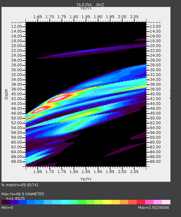
| Estimated Moho Depth: |
46.5 km |
| Estimated Crust Vp/Vs: |
1.65 |
| Assumed Crust Vp: |
6.419 km/s |
| Estimated Crust Vs: |
3.885 km/s |
| Estimated Crust Poisson's Ratio: |
0.21 |
|
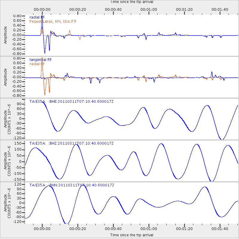
| Radial Match: |
85.85741 % |
| Radial Bump: |
400 |
| Transverse Match: |
49.822838 % |
| Transverse Bump: |
214 |
| SOD ConfigId: |
356183 |
| Insert Time: |
2011-08-11 06:03:57.118 +0000 |
| GWidth: |
2.5 |
| Max Bumps: |
400 |
| Tol: |
0.001 |
|
Signal To Noise
| Channel | StoN | STA | LTA |
| TA:E35A: :BHZ:20110311T07:10:40.600017Z | 0.5407655 | 5.5313067E-5 | 1.022866E-4 |
| TA:E35A: :BHN:20110311T07:10:40.600017Z | 2.02619 | 1.1677399E-4 | 5.76323E-5 |
| TA:E35A: :BHE:20110311T07:10:40.600017Z | 0.18943785 | 9.49553E-6 | 5.012478E-5 |
| Arrivals |
| Ps | 4.9 SECOND |
| PpPs | 19 SECOND |
| PsPs/PpSs | 24 SECOND |


