You are here: Home > Network List > TA - USArray Transportable Network (new EarthScope stations) Stations List
> Station B33A Robert and Kassanda Mosher, Grygla, MN, USA > Earthquake Result Viewer
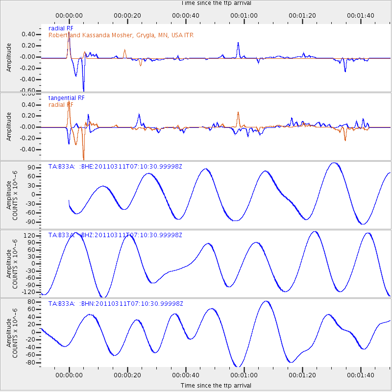
B33A Robert and Kassanda Mosher, Grygla, MN, USA - Earthquake Result Viewer
*The percent match for this event was below the threshold and hence no stack was calculated.
| Earthquake location: |
Off East Coast Of Honshu, Japan |
| Earthquake latitude/longitude: |
37.4/144.7 |
| Earthquake time(UTC): |
2011/03/11 (070) 06:59:00 GMT |
| Earthquake Depth: |
36 km |
| Earthquake Magnitude: |
6.3 MB |
| Earthquake Catalog/Contributor: |
WHDF/NEIC |
|
| Network: |
TA USArray Transportable Network (new EarthScope stations) |
| Station: |
B33A Robert and Kassanda Mosher, Grygla, MN, USA |
| Lat/Lon: |
48.27 N/95.59 W |
| Elevation: |
362 m |
|
| Distance: |
79.3 deg |
| Az: |
36.206 deg |
| Baz: |
315.209 deg |
| Ray Param: |
$rayparam |
*The percent match for this event was below the threshold and hence was not used in the summary stack. |
|
| Radial Match: |
94.10897 % |
| Radial Bump: |
399 |
| Transverse Match: |
72.43111 % |
| Transverse Bump: |
400 |
| SOD ConfigId: |
356183 |
| Insert Time: |
2011-08-11 06:07:17.709 +0000 |
| GWidth: |
2.5 |
| Max Bumps: |
400 |
| Tol: |
0.001 |
|
Signal To Noise
| Channel | StoN | STA | LTA |
| TA:B33A: :BHZ:20110311T07:10:30.99998Z | 1.9539318 | 1.395452E-4 | 7.141764E-5 |
| TA:B33A: :BHN:20110311T07:10:30.99998Z | 0.8909721 | 2.3255065E-5 | 2.6100777E-5 |
| TA:B33A: :BHE:20110311T07:10:30.99998Z | 1.3609713 | 4.347077E-5 | 3.194099E-5 |
| Arrivals |
| Ps | |
| PpPs | |
| PsPs/PpSs | |


