You are here: Home > Network List > TA - USArray Transportable Network (new EarthScope stations) Stations List
> Station M38A Pleasantville, IA, USA > Earthquake Result Viewer
M38A Pleasantville, IA, USA - Earthquake Result Viewer
| Earthquake location: |
Off East Coast Of Honshu, Japan |
| Earthquake latitude/longitude: |
37.4/144.7 |
| Earthquake time(UTC): |
2011/03/11 (070) 06:59:00 GMT |
| Earthquake Depth: |
36 km |
| Earthquake Magnitude: |
6.3 MB |
| Earthquake Catalog/Contributor: |
WHDF/NEIC |
|
| Network: |
TA USArray Transportable Network (new EarthScope stations) |
| Station: |
M38A Pleasantville, IA, USA |
| Lat/Lon: |
41.42 N/93.20 W |
| Elevation: |
258 m |
|
| Distance: |
85.4 deg |
| Az: |
39.741 deg |
| Baz: |
317.364 deg |
| Ray Param: |
0.04473054 |
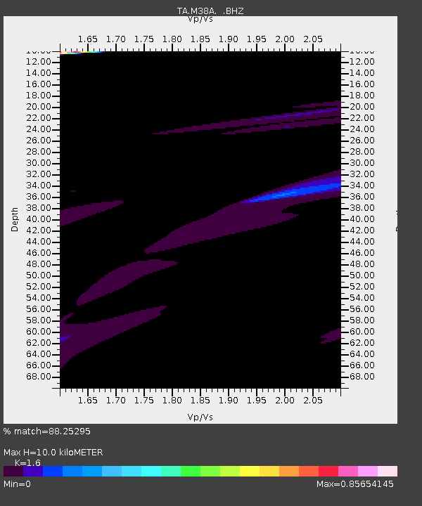
| Estimated Moho Depth: |
10.0 km |
| Estimated Crust Vp/Vs: |
1.60 |
| Assumed Crust Vp: |
6.498 km/s |
| Estimated Crust Vs: |
4.061 km/s |
| Estimated Crust Poisson's Ratio: |
0.18 |
|
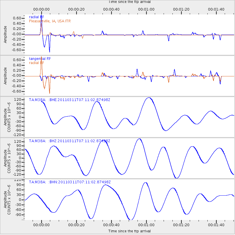
| Radial Match: |
88.25295 % |
| Radial Bump: |
289 |
| Transverse Match: |
53.839226 % |
| Transverse Bump: |
307 |
| SOD ConfigId: |
356183 |
| Insert Time: |
2011-08-11 06:08:20.089 +0000 |
| GWidth: |
2.5 |
| Max Bumps: |
400 |
| Tol: |
0.001 |
|
Signal To Noise
| Channel | StoN | STA | LTA |
| TA:M38A: :BHZ:20110311T07:11:02.87498Z | 2.0957987 | 8.019947E-5 | 3.8266782E-5 |
| TA:M38A: :BHN:20110311T07:11:02.87498Z | 3.804799 | 3.9233426E-5 | 1.03115635E-5 |
| TA:M38A: :BHE:20110311T07:11:02.87498Z | 2.0525641 | 9.589906E-5 | 4.6721587E-5 |
| Arrivals |
| Ps | 0.9 SECOND |
| PpPs | 3.9 SECOND |
| PsPs/PpSs | 4.8 SECOND |


