You are here: Home > Network List > TA - USArray Transportable Network (new EarthScope stations) Stations List
> Station L37A Phoenix Point, Boone, IA, USA > Earthquake Result Viewer
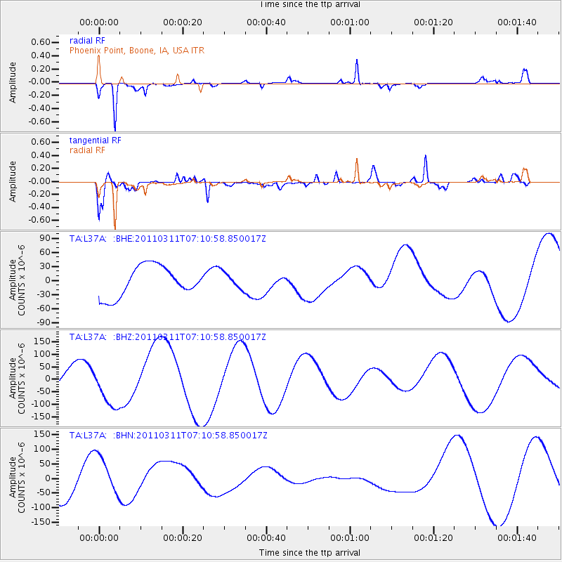
L37A Phoenix Point, Boone, IA, USA - Earthquake Result Viewer
*The percent match for this event was below the threshold and hence no stack was calculated.
| Earthquake location: |
Off East Coast Of Honshu, Japan |
| Earthquake latitude/longitude: |
37.4/144.7 |
| Earthquake time(UTC): |
2011/03/11 (070) 06:59:00 GMT |
| Earthquake Depth: |
36 km |
| Earthquake Magnitude: |
6.3 MB |
| Earthquake Catalog/Contributor: |
WHDF/NEIC |
|
| Network: |
TA USArray Transportable Network (new EarthScope stations) |
| Station: |
L37A Phoenix Point, Boone, IA, USA |
| Lat/Lon: |
42.12 N/93.75 W |
| Elevation: |
312 m |
|
| Distance: |
84.6 deg |
| Az: |
39.566 deg |
| Baz: |
316.978 deg |
| Ray Param: |
$rayparam |
*The percent match for this event was below the threshold and hence was not used in the summary stack. |
|
| Radial Match: |
81.71644 % |
| Radial Bump: |
400 |
| Transverse Match: |
65.09136 % |
| Transverse Bump: |
400 |
| SOD ConfigId: |
356183 |
| Insert Time: |
2011-08-11 06:08:20.416 +0000 |
| GWidth: |
2.5 |
| Max Bumps: |
400 |
| Tol: |
0.001 |
|
Signal To Noise
| Channel | StoN | STA | LTA |
| TA:L37A: :BHZ:20110311T07:10:58.850017Z | 2.8230112 | 8.7655404E-5 | 3.105032E-5 |
| TA:L37A: :BHN:20110311T07:10:58.850017Z | 1.3301597 | 7.2956034E-5 | 5.4847576E-5 |
| TA:L37A: :BHE:20110311T07:10:58.850017Z | 0.5255829 | 1.688798E-5 | 3.2131902E-5 |
| Arrivals |
| Ps | |
| PpPs | |
| PsPs/PpSs | |


