You are here: Home > Network List > US - United States National Seismic Network Stations List
> Station DGMT Dagmar, Montana, USA > Earthquake Result Viewer
DGMT Dagmar, Montana, USA - Earthquake Result Viewer

| Earthquake location: |
Off East Coast Of Honshu, Japan |
| Earthquake latitude/longitude: |
37.4/144.7 |
| Earthquake time(UTC): |
2011/03/11 (070) 06:59:00 GMT |
| Earthquake Depth: |
36 km |
| Earthquake Magnitude: |
6.3 MB |
| Earthquake Catalog/Contributor: |
WHDF/NEIC |
|
| Network: |
US United States National Seismic Network |
| Station: |
DGMT Dagmar, Montana, USA |
| Lat/Lon: |
48.47 N/104.20 W |
| Elevation: |
0.0 m |
|
| Distance: |
74.9 deg |
| Az: |
40.026 deg |
| Baz: |
309.643 deg |
| Ray Param: |
0.051959094 |
| Estimated Moho Depth: |
52.0 km |
| Estimated Crust Vp/Vs: |
1.65 |
| Assumed Crust Vp: |
6.438 km/s |
| Estimated Crust Vs: |
3.907 km/s |
| Estimated Crust Poisson's Ratio: |
0.21 |
|
| Radial Match: |
82.78017 % |
| Radial Bump: |
376 |
| Transverse Match: |
61.36921 % |
| Transverse Bump: |
371 |
| SOD ConfigId: |
356183 |
| Insert Time: |
2011-08-11 06:18:11.850 +0000 |
| GWidth: |
2.5 |
| Max Bumps: |
400 |
| Tol: |
0.001 |
|
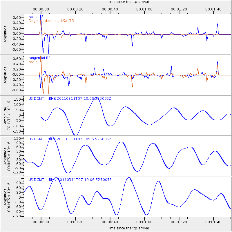
Signal To Noise
| Channel | StoN | STA | LTA |
| US:DGMT: :BHZ:20110311T07:10:06.525005Z | 0.70454997 | 6.475801E-5 | 9.191401E-5 |
| US:DGMT: :BHN:20110311T07:10:06.525005Z | 0.7446214 | 4.497652E-5 | 6.0401864E-5 |
| US:DGMT: :BHE:20110311T07:10:06.525005Z | 2.1847744 | 1.8182123E-4 | 8.322197E-5 |
| Arrivals |
| Ps | 5.4 SECOND |
| PpPs | 21 SECOND |
| PsPs/PpSs | 26 SECOND |


