You are here: Home > Network List > UW - Pacific Northwest Regional Seismic Network Stations List
> Station LEBA Lebam, WA, USA > Earthquake Result Viewer
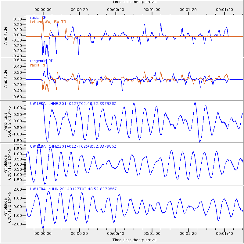
LEBA Lebam, WA, USA - Earthquake Result Viewer
*The percent match for this event was below the threshold and hence no stack was calculated.
| Earthquake location: |
New Ireland Region, P.N.G. |
| Earthquake latitude/longitude: |
-4.4/153.1 |
| Earthquake time(UTC): |
2014/01/27 (027) 02:36:35 GMT |
| Earthquake Depth: |
38 km |
| Earthquake Magnitude: |
5.1 mb |
| Earthquake Catalog/Contributor: |
ISC/ISC |
|
| Network: |
UW Pacific Northwest Regional Seismic Network |
| Station: |
LEBA Lebam, WA, USA |
| Lat/Lon: |
46.55 N/123.56 W |
| Elevation: |
73 m |
|
| Distance: |
88.5 deg |
| Az: |
43.294 deg |
| Baz: |
262.185 deg |
| Ray Param: |
$rayparam |
*The percent match for this event was below the threshold and hence was not used in the summary stack. |
|
| Radial Match: |
71.82276 % |
| Radial Bump: |
389 |
| Transverse Match: |
67.38471 % |
| Transverse Bump: |
382 |
| SOD ConfigId: |
3390531 |
| Insert Time: |
2019-04-10 03:41:23.564 +0000 |
| GWidth: |
2.5 |
| Max Bumps: |
400 |
| Tol: |
0.001 |
|
Signal To Noise
| Channel | StoN | STA | LTA |
| UW:LEBA: :HHZ:20140127T02:48:52.837986Z | 2.2799993 | 1.2991098E-6 | 5.697852E-7 |
| UW:LEBA: :HHN:20140127T02:48:52.837986Z | 3.1649797 | 1.5435725E-6 | 4.8770374E-7 |
| UW:LEBA: :HHE:20140127T02:48:52.837986Z | 1.1253763 | 8.600101E-7 | 7.6419775E-7 |
| Arrivals |
| Ps | |
| PpPs | |
| PsPs/PpSs | |


