You are here: Home > Network List > TA - USArray Transportable Network (new EarthScope stations) Stations List
> Station D29A Pettibone, Tappen, ND, USA > Earthquake Result Viewer
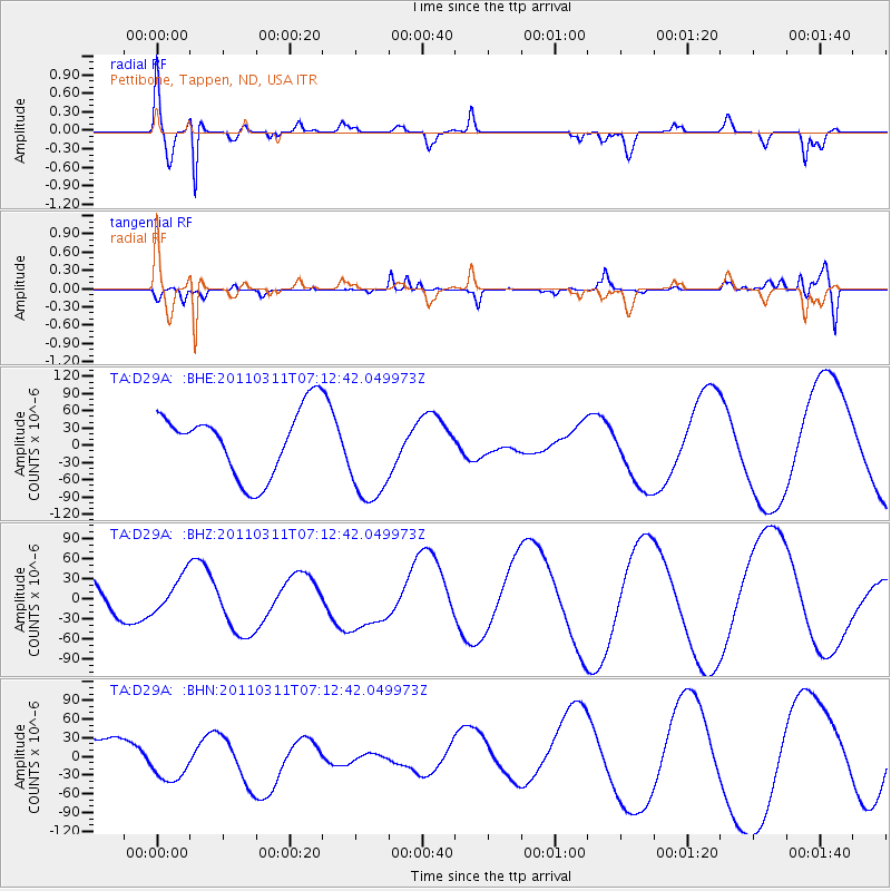
D29A Pettibone, Tappen, ND, USA - Earthquake Result Viewer
*The percent match for this event was below the threshold and hence no stack was calculated.
| Earthquake location: |
Off East Coast Of Honshu, Japan |
| Earthquake latitude/longitude: |
36.6/143.8 |
| Earthquake time(UTC): |
2011/03/11 (070) 07:01:11 GMT |
| Earthquake Depth: |
36 km |
| Earthquake Magnitude: |
5.7 MB |
| Earthquake Catalog/Contributor: |
WHDF/NEIC |
|
| Network: |
TA USArray Transportable Network (new EarthScope stations) |
| Station: |
D29A Pettibone, Tappen, ND, USA |
| Lat/Lon: |
47.06 N/99.60 W |
| Elevation: |
551 m |
|
| Distance: |
79.2 deg |
| Az: |
38.462 deg |
| Baz: |
312.957 deg |
| Ray Param: |
$rayparam |
*The percent match for this event was below the threshold and hence was not used in the summary stack. |
|
| Radial Match: |
75.033745 % |
| Radial Bump: |
400 |
| Transverse Match: |
45.381824 % |
| Transverse Bump: |
400 |
| SOD ConfigId: |
356183 |
| Insert Time: |
2011-08-11 07:16:39.029 +0000 |
| GWidth: |
2.5 |
| Max Bumps: |
400 |
| Tol: |
0.001 |
|
Signal To Noise
| Channel | StoN | STA | LTA |
| TA:D29A: :BHZ:20110311T07:12:42.049973Z | 1.5617287 | 2.645856E-5 | 1.694184E-5 |
| TA:D29A: :BHN:20110311T07:12:42.049973Z | 1.191899 | 3.458434E-5 | 2.901617E-5 |
| TA:D29A: :BHE:20110311T07:12:42.049973Z | 1.5595558 | 8.954166E-5 | 5.7414847E-5 |
| Arrivals |
| Ps | |
| PpPs | |
| PsPs/PpSs | |


