You are here: Home > Network List > TA - USArray Transportable Network (new EarthScope stations) Stations List
> Station 934A Benavides, TX, USA > Earthquake Result Viewer
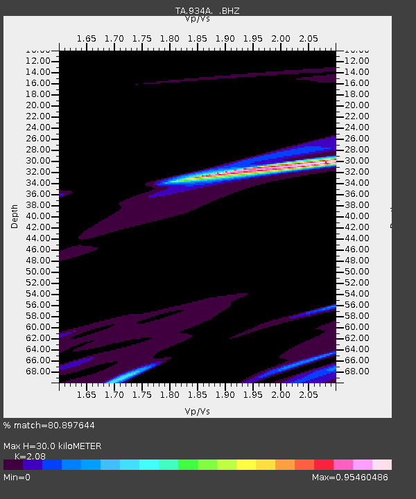
934A Benavides, TX, USA - Earthquake Result Viewer
| Earthquake location: |
Off East Coast Of Honshu, Japan |
| Earthquake latitude/longitude: |
36.6/143.8 |
| Earthquake time(UTC): |
2011/03/11 (070) 07:01:11 GMT |
| Earthquake Depth: |
36 km |
| Earthquake Magnitude: |
5.7 MB |
| Earthquake Catalog/Contributor: |
WHDF/NEIC |
|
| Network: |
TA USArray Transportable Network (new EarthScope stations) |
| Station: |
934A Benavides, TX, USA |
| Lat/Lon: |
27.60 N/98.52 W |
| Elevation: |
144 m |
|
| Distance: |
93.3 deg |
| Az: |
51.897 deg |
| Baz: |
314.497 deg |
| Ray Param: |
0.041266404 |
| Estimated Moho Depth: |
30.0 km |
| Estimated Crust Vp/Vs: |
2.08 |
| Assumed Crust Vp: |
6.096 km/s |
| Estimated Crust Vs: |
2.931 km/s |
| Estimated Crust Poisson's Ratio: |
0.35 |
|
| Radial Match: |
80.897644 % |
| Radial Bump: |
315 |
| Transverse Match: |
86.62002 % |
| Transverse Bump: |
224 |
| SOD ConfigId: |
356183 |
| Insert Time: |
2011-08-11 07:22:53.516 +0000 |
| GWidth: |
2.5 |
| Max Bumps: |
400 |
| Tol: |
0.001 |
|

Signal To Noise
| Channel | StoN | STA | LTA |
| TA:934A: :BHZ:20110311T07:13:51.574998Z | 0.54976124 | 6.196187E-5 | 1.1270688E-4 |
| TA:934A: :BHN:20110311T07:13:51.574998Z | 2.0221918 | 3.9176943E-4 | 1.9373505E-4 |
| TA:934A: :BHE:20110311T07:13:51.574998Z | 0.64377135 | 4.277883E-5 | 6.6450346E-5 |
| Arrivals |
| Ps | 5.4 SECOND |
| PpPs | 15 SECOND |
| PsPs/PpSs | 20 SECOND |


