You are here: Home > Network List > TA - USArray Transportable Network (new EarthScope stations) Stations List
> Station 337A Centerville, TX, USA > Earthquake Result Viewer
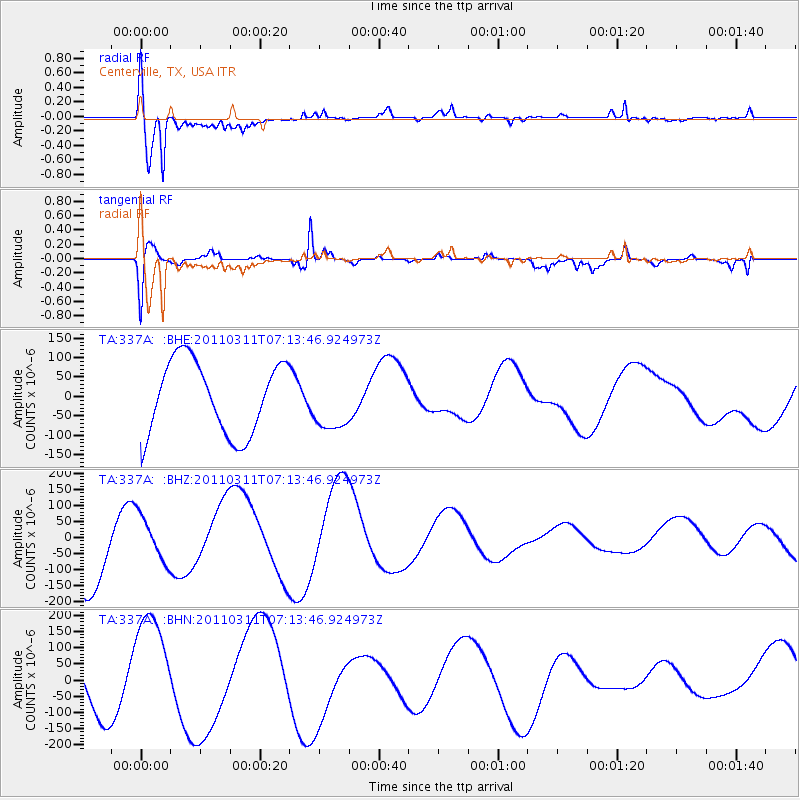
337A Centerville, TX, USA - Earthquake Result Viewer
| Earthquake location: |
Off East Coast Of Honshu, Japan |
| Earthquake latitude/longitude: |
36.6/143.8 |
| Earthquake time(UTC): |
2011/03/11 (070) 07:01:11 GMT |
| Earthquake Depth: |
36 km |
| Earthquake Magnitude: |
5.7 MB |
| Earthquake Catalog/Contributor: |
WHDF/NEIC |
|
| Network: |
TA USArray Transportable Network (new EarthScope stations) |
| Station: |
337A Centerville, TX, USA |
| Lat/Lon: |
31.32 N/95.89 W |
| Elevation: |
150 m |
|
| Distance: |
92.3 deg |
| Az: |
47.656 deg |
| Baz: |
315.996 deg |
| Ray Param: |
0.041464116 |
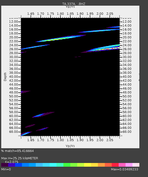
| Estimated Moho Depth: |
25.25 km |
| Estimated Crust Vp/Vs: |
2.08 |
| Assumed Crust Vp: |
5.738 km/s |
| Estimated Crust Vs: |
2.766 km/s |
| Estimated Crust Poisson's Ratio: |
0.35 |
|
| Radial Match: |
85.416664 % |
| Radial Bump: |
400 |
| Transverse Match: |
78.37553 % |
| Transverse Bump: |
394 |
| SOD ConfigId: |
356183 |
| Insert Time: |
2011-08-11 07:24:15.468 +0000 |
| GWidth: |
2.5 |
| Max Bumps: |
400 |
| Tol: |
0.001 |
|
Signal To Noise
| Channel | StoN | STA | LTA |
| TA:337A: :BHZ:20110311T07:13:46.924973Z | 0.64341 | 7.157248E-5 | 1.1123931E-4 |
| TA:337A: :BHN:20110311T07:13:46.924973Z | 2.5892122 | 1.7416023E-4 | 6.726379E-5 |
| TA:337A: :BHE:20110311T07:13:46.924973Z | 0.78131026 | 7.326969E-5 | 9.377798E-5 |
| Arrivals |
| Ps | 4.8 SECOND |
| PpPs | 13 SECOND |
| PsPs/PpSs | 18 SECOND |


