You are here: Home > Network List > TA - USArray Transportable Network (new EarthScope stations) Stations List
> Station Y38A Idabel, OK, USA > Earthquake Result Viewer
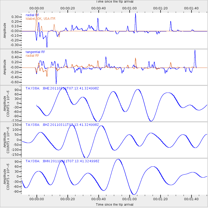
Y38A Idabel, OK, USA - Earthquake Result Viewer
*The percent match for this event was below the threshold and hence no stack was calculated.
| Earthquake location: |
Off East Coast Of Honshu, Japan |
| Earthquake latitude/longitude: |
36.6/143.8 |
| Earthquake time(UTC): |
2011/03/11 (070) 07:01:11 GMT |
| Earthquake Depth: |
36 km |
| Earthquake Magnitude: |
5.7 MB |
| Earthquake Catalog/Contributor: |
WHDF/NEIC |
|
| Network: |
TA USArray Transportable Network (new EarthScope stations) |
| Station: |
Y38A Idabel, OK, USA |
| Lat/Lon: |
33.93 N/94.73 W |
| Elevation: |
118 m |
|
| Distance: |
91.1 deg |
| Az: |
45.152 deg |
| Baz: |
316.691 deg |
| Ray Param: |
$rayparam |
*The percent match for this event was below the threshold and hence was not used in the summary stack. |
|
| Radial Match: |
64.92215 % |
| Radial Bump: |
393 |
| Transverse Match: |
69.593864 % |
| Transverse Bump: |
400 |
| SOD ConfigId: |
356183 |
| Insert Time: |
2011-08-11 07:27:20.516 +0000 |
| GWidth: |
2.5 |
| Max Bumps: |
400 |
| Tol: |
0.001 |
|
Signal To Noise
| Channel | StoN | STA | LTA |
| TA:Y38A: :BHZ:20110311T07:13:41.324998Z | 7.4994273 | 7.5271244E-5 | 1.00369325E-5 |
| TA:Y38A: :BHN:20110311T07:13:41.324998Z | 0.7893586 | 4.136125E-5 | 5.239856E-5 |
| TA:Y38A: :BHE:20110311T07:13:41.324998Z | 0.48404607 | 3.060916E-5 | 6.3236046E-5 |
| Arrivals |
| Ps | |
| PpPs | |
| PsPs/PpSs | |


