You are here: Home > Network List > XG92 - Rocky Mountain Front Stations List
> Station ORD near Forder, CO > Earthquake Result Viewer
ORD near Forder, CO - Earthquake Result Viewer

| Earthquake location: |
Northern Peru |
| Earthquake latitude/longitude: |
-3.9/-76.6 |
| Earthquake time(UTC): |
1992/07/13 (195) 18:11:34 GMT |
| Earthquake Depth: |
100 km |
| Earthquake Magnitude: |
6.2 MB |
| Earthquake Catalog/Contributor: |
WHDF/NEIC |
|
| Network: |
XG Rocky Mountain Front |
| Station: |
ORD near Forder, CO |
| Lat/Lon: |
38.53 N/103.71 W |
| Elevation: |
1436 m |
|
| Distance: |
49.1 deg |
| Az: |
331.819 deg |
| Baz: |
143.077 deg |
| Ray Param: |
0.06858522 |
| Estimated Moho Depth: |
47.25 km |
| Estimated Crust Vp/Vs: |
1.71 |
| Assumed Crust Vp: |
6.242 km/s |
| Estimated Crust Vs: |
3.645 km/s |
| Estimated Crust Poisson's Ratio: |
0.24 |
|
| Radial Match: |
84.05674 % |
| Radial Bump: |
400 |
| Transverse Match: |
78.410934 % |
| Transverse Bump: |
400 |
| SOD ConfigId: |
3286 |
| Insert Time: |
2010-02-25 20:10:48.959 +0000 |
| GWidth: |
2.5 |
| Max Bumps: |
400 |
| Tol: |
0.001 |
|
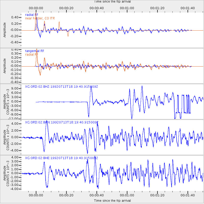
Signal To Noise
| Channel | StoN | STA | LTA |
| XG:ORD:02:BHN:19920713T18:19:40.915009Z | 6.977727 | 6.0539297E-4 | 8.6760774E-5 |
| XG:ORD:02:BHE:19920713T18:19:40.915009Z | 5.275494 | 4.2689516E-4 | 8.0920414E-5 |
| XG:ORD:02:BHZ:19920713T18:19:40.915009Z | 54.339302 | 0.0029301431 | 5.3923093E-5 |
| Arrivals |
| Ps | 5.7 SECOND |
| PpPs | 19 SECOND |
| PsPs/PpSs | 25 SECOND |


