You are here: Home > Network List > TA - USArray Transportable Network (new EarthScope stations) Stations List
> Station N23A Red Feather Lakes, CO, USA > Earthquake Result Viewer
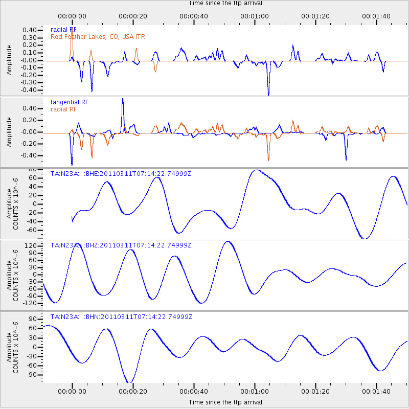
N23A Red Feather Lakes, CO, USA - Earthquake Result Viewer
*The percent match for this event was below the threshold and hence no stack was calculated.
| Earthquake location: |
Near East Coast Of Honshu, Japan |
| Earthquake latitude/longitude: |
39.7/142.5 |
| Earthquake time(UTC): |
2011/03/11 (070) 07:02:57 GMT |
| Earthquake Depth: |
42 km |
| Earthquake Magnitude: |
5.8 MB |
| Earthquake Catalog/Contributor: |
WHDF/NEIC |
|
| Network: |
TA USArray Transportable Network (new EarthScope stations) |
| Station: |
N23A Red Feather Lakes, CO, USA |
| Lat/Lon: |
40.89 N/105.94 W |
| Elevation: |
2458 m |
|
| Distance: |
78.4 deg |
| Az: |
46.036 deg |
| Baz: |
312.896 deg |
| Ray Param: |
$rayparam |
*The percent match for this event was below the threshold and hence was not used in the summary stack. |
|
| Radial Match: |
77.346886 % |
| Radial Bump: |
400 |
| Transverse Match: |
61.9164 % |
| Transverse Bump: |
265 |
| SOD ConfigId: |
356183 |
| Insert Time: |
2011-08-11 08:42:35.306 +0000 |
| GWidth: |
2.5 |
| Max Bumps: |
400 |
| Tol: |
0.001 |
|
Signal To Noise
| Channel | StoN | STA | LTA |
| TA:N23A: :BHZ:20110311T07:14:22.74999Z | 1.659317 | 1.10717694E-4 | 6.672486E-5 |
| TA:N23A: :BHN:20110311T07:14:22.74999Z | 0.7726029 | 3.624238E-5 | 4.6909452E-5 |
| TA:N23A: :BHE:20110311T07:14:22.74999Z | 1.7659382 | 4.3570144E-5 | 2.467252E-5 |
| Arrivals |
| Ps | |
| PpPs | |
| PsPs/PpSs | |


