You are here: Home > Network List > TA - USArray Transportable Network (new EarthScope stations) Stations List
> Station Q28A Sharon Springs, KS, USA > Earthquake Result Viewer
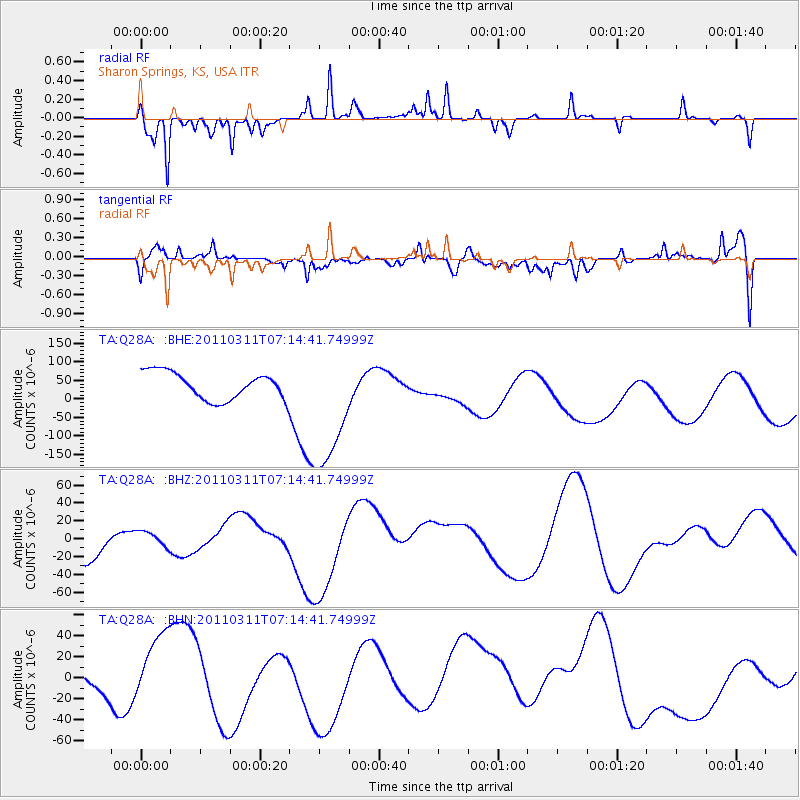
Q28A Sharon Springs, KS, USA - Earthquake Result Viewer
*The percent match for this event was below the threshold and hence no stack was calculated.
| Earthquake location: |
Near East Coast Of Honshu, Japan |
| Earthquake latitude/longitude: |
39.7/142.5 |
| Earthquake time(UTC): |
2011/03/11 (070) 07:02:57 GMT |
| Earthquake Depth: |
42 km |
| Earthquake Magnitude: |
5.8 MB |
| Earthquake Catalog/Contributor: |
WHDF/NEIC |
|
| Network: |
TA USArray Transportable Network (new EarthScope stations) |
| Station: |
Q28A Sharon Springs, KS, USA |
| Lat/Lon: |
39.06 N/101.83 W |
| Elevation: |
1133 m |
|
| Distance: |
82.0 deg |
| Az: |
45.135 deg |
| Baz: |
315.376 deg |
| Ray Param: |
$rayparam |
*The percent match for this event was below the threshold and hence was not used in the summary stack. |
|
| Radial Match: |
57.97812 % |
| Radial Bump: |
183 |
| Transverse Match: |
26.532074 % |
| Transverse Bump: |
400 |
| SOD ConfigId: |
356183 |
| Insert Time: |
2011-08-11 08:44:26.582 +0000 |
| GWidth: |
2.5 |
| Max Bumps: |
400 |
| Tol: |
0.001 |
|
Signal To Noise
| Channel | StoN | STA | LTA |
| TA:Q28A: :BHZ:20110311T07:14:41.74999Z | 0.3145968 | 9.568612E-6 | 3.0415476E-5 |
| TA:Q28A: :BHN:20110311T07:14:41.74999Z | 0.768287 | 2.8262853E-5 | 3.678684E-5 |
| TA:Q28A: :BHE:20110311T07:14:41.74999Z | 4.7978573 | 1.7492396E-4 | 3.645877E-5 |
| Arrivals |
| Ps | |
| PpPs | |
| PsPs/PpSs | |


