You are here: Home > Network List > TA - USArray Transportable Network (new EarthScope stations) Stations List
> Station J04D Umpqua National Forest, Toketee, OR, USA > Earthquake Result Viewer
J04D Umpqua National Forest, Toketee, OR, USA - Earthquake Result Viewer
| Earthquake location: |
Near East Coast Of Honshu, Japan |
| Earthquake latitude/longitude: |
39.7/142.5 |
| Earthquake time(UTC): |
2011/03/11 (070) 07:02:57 GMT |
| Earthquake Depth: |
42 km |
| Earthquake Magnitude: |
5.8 MB |
| Earthquake Catalog/Contributor: |
WHDF/NEIC |
|
| Network: |
TA USArray Transportable Network (new EarthScope stations) |
| Station: |
J04D Umpqua National Forest, Toketee, OR, USA |
| Lat/Lon: |
43.24 N/122.11 W |
| Elevation: |
1948 m |
|
| Distance: |
67.6 deg |
| Az: |
51.918 deg |
| Baz: |
303.791 deg |
| Ray Param: |
0.056794126 |
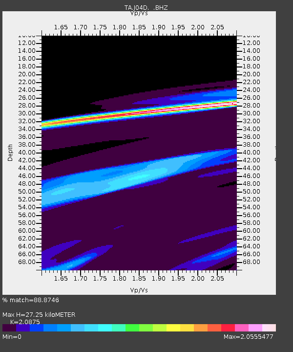
| Estimated Moho Depth: |
27.25 km |
| Estimated Crust Vp/Vs: |
2.09 |
| Assumed Crust Vp: |
6.522 km/s |
| Estimated Crust Vs: |
3.124 km/s |
| Estimated Crust Poisson's Ratio: |
0.35 |
|
| Radial Match: |
88.8746 % |
| Radial Bump: |
400 |
| Transverse Match: |
64.35992 % |
| Transverse Bump: |
400 |
| SOD ConfigId: |
356183 |
| Insert Time: |
2011-08-11 08:51:45.927 +0000 |
| GWidth: |
2.5 |
| Max Bumps: |
400 |
| Tol: |
0.001 |
|

Signal To Noise
| Channel | StoN | STA | LTA |
| TA:J04D: :BHZ:20110311T07:13:18.62499Z | 0.81389934 | 6.8715155E-5 | 8.442709E-5 |
| TA:J04D: :BHN:20110311T07:13:18.62499Z | 0.8344504 | 3.1131673E-5 | 3.7307993E-5 |
| TA:J04D: :BHE:20110311T07:13:18.62499Z | 0.61457175 | 4.2164516E-5 | 6.8607966E-5 |
| Arrivals |
| Ps | 4.7 SECOND |
| PpPs | 12 SECOND |
| PsPs/PpSs | 17 SECOND |


