You are here: Home > Network List > TA - USArray Transportable Network (new EarthScope stations) Stations List
> Station F04D Rainier, OR, USA > Earthquake Result Viewer
F04D Rainier, OR, USA - Earthquake Result Viewer
| Earthquake location: |
Near East Coast Of Honshu, Japan |
| Earthquake latitude/longitude: |
39.7/142.5 |
| Earthquake time(UTC): |
2011/03/11 (070) 07:02:57 GMT |
| Earthquake Depth: |
42 km |
| Earthquake Magnitude: |
5.8 MB |
| Earthquake Catalog/Contributor: |
WHDF/NEIC |
|
| Network: |
TA USArray Transportable Network (new EarthScope stations) |
| Station: |
F04D Rainier, OR, USA |
| Lat/Lon: |
46.08 N/123.01 W |
| Elevation: |
236 m |
|
| Distance: |
65.5 deg |
| Az: |
49.703 deg |
| Baz: |
302.276 deg |
| Ray Param: |
0.05816457 |
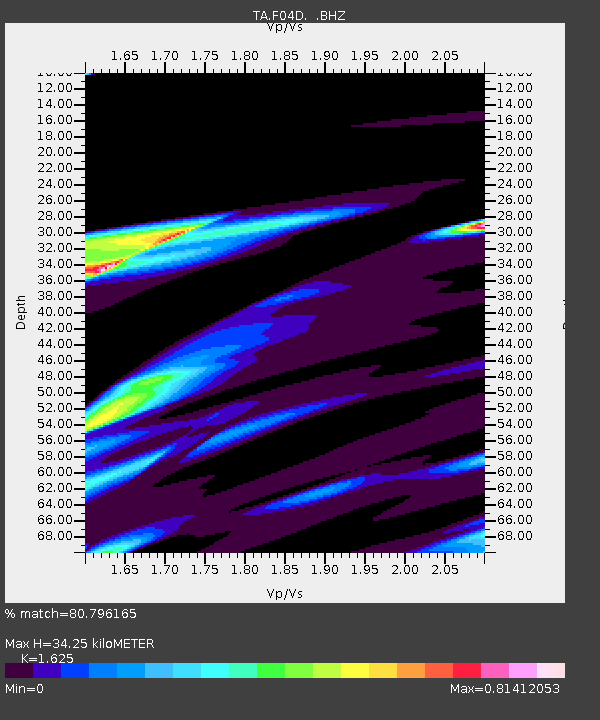
| Estimated Moho Depth: |
34.25 km |
| Estimated Crust Vp/Vs: |
1.62 |
| Assumed Crust Vp: |
6.566 km/s |
| Estimated Crust Vs: |
4.041 km/s |
| Estimated Crust Poisson's Ratio: |
0.20 |
|
| Radial Match: |
80.796165 % |
| Radial Bump: |
400 |
| Transverse Match: |
62.176594 % |
| Transverse Bump: |
400 |
| SOD ConfigId: |
356183 |
| Insert Time: |
2011-08-11 08:54:28.377 +0000 |
| GWidth: |
2.5 |
| Max Bumps: |
400 |
| Tol: |
0.001 |
|

Signal To Noise
| Channel | StoN | STA | LTA |
| TA:F04D: :BHZ:20110311T07:13:05.325002Z | 1.986769 | 4.704156E-5 | 2.367742E-5 |
| TA:F04D: :BHN:20110311T07:13:05.325002Z | 0.43445143 | 1.0902284E-5 | 2.5094369E-5 |
| TA:F04D: :BHE:20110311T07:13:05.325002Z | 2.4978304 | 9.275828E-5 | 3.7135538E-5 |
| Arrivals |
| Ps | 3.4 SECOND |
| PpPs | 13 SECOND |
| PsPs/PpSs | 16 SECOND |


