You are here: Home > Network List > TA - USArray Transportable Network (new EarthScope stations) Stations List
> Station 335A Moody, TX, USA > Earthquake Result Viewer
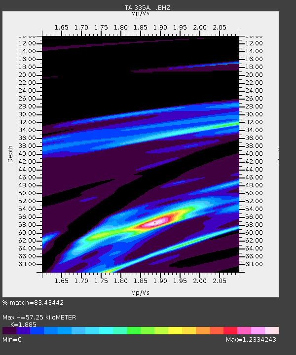
335A Moody, TX, USA - Earthquake Result Viewer
| Earthquake location: |
Near East Coast Of Honshu, Japan |
| Earthquake latitude/longitude: |
39.7/142.5 |
| Earthquake time(UTC): |
2011/03/11 (070) 07:02:57 GMT |
| Earthquake Depth: |
42 km |
| Earthquake Magnitude: |
5.8 MB |
| Earthquake Catalog/Contributor: |
WHDF/NEIC |
|
| Network: |
TA USArray Transportable Network (new EarthScope stations) |
| Station: |
335A Moody, TX, USA |
| Lat/Lon: |
31.28 N/97.43 W |
| Elevation: |
217 m |
|
| Distance: |
90.1 deg |
| Az: |
47.828 deg |
| Baz: |
318.094 deg |
| Ray Param: |
0.041690387 |
| Estimated Moho Depth: |
57.25 km |
| Estimated Crust Vp/Vs: |
1.88 |
| Assumed Crust Vp: |
6.347 km/s |
| Estimated Crust Vs: |
3.367 km/s |
| Estimated Crust Poisson's Ratio: |
0.30 |
|
| Radial Match: |
83.43442 % |
| Radial Bump: |
400 |
| Transverse Match: |
63.90616 % |
| Transverse Bump: |
400 |
| SOD ConfigId: |
356183 |
| Insert Time: |
2011-08-11 08:54:34.362 +0000 |
| GWidth: |
2.5 |
| Max Bumps: |
400 |
| Tol: |
0.001 |
|

Signal To Noise
| Channel | StoN | STA | LTA |
| TA:335A: :BHZ:20110311T07:15:21.674978Z | 2.2579718 | 1.4034618E-4 | 6.215586E-5 |
| TA:335A: :BHN:20110311T07:15:21.674978Z | 0.4890883 | 2.025529E-5 | 4.141438E-5 |
| TA:335A: :BHE:20110311T07:15:21.674978Z | 0.56303763 | 5.118908E-5 | 9.091591E-5 |
| Arrivals |
| Ps | 8.1 SECOND |
| PpPs | 26 SECOND |
| PsPs/PpSs | 34 SECOND |


