You are here: Home > Network List > TA - USArray Transportable Network (new EarthScope stations) Stations List
> Station O33A Hebron, NE, USA > Earthquake Result Viewer
O33A Hebron, NE, USA - Earthquake Result Viewer
| Earthquake location: |
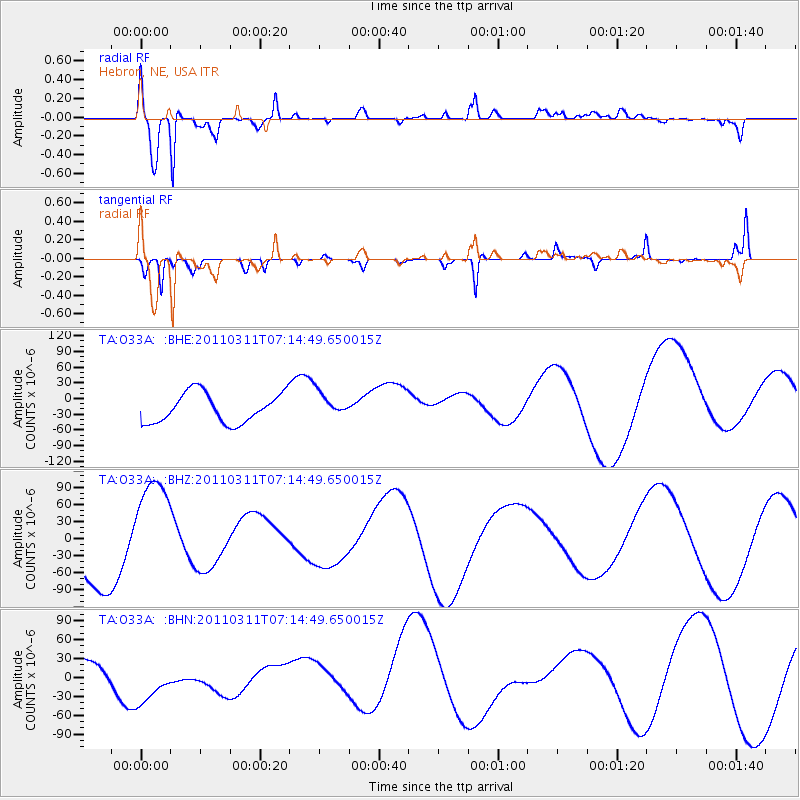
Near East Coast Of Honshu, Japan |
| Earthquake latitude/longitude: |
39.7/142.5 |
| Earthquake time(UTC): |
2011/03/11 (070) 07:02:57 GMT |
| Earthquake Depth: |
42 km |
| Earthquake Magnitude: |
5.8 MB |
| Earthquake Catalog/Contributor: |
WHDF/NEIC |
|
| Network: |
TA USArray Transportable Network (new EarthScope stations) |
| Station: |
O33A Hebron, NE, USA |
| Lat/Lon: |
40.08 N/97.58 W |
| Elevation: |
480 m |
|
| Distance: |
83.5 deg |
| Az: |
42.033 deg |
| Baz: |
317.679 deg |
| Ray Param: |
0.046067085 |
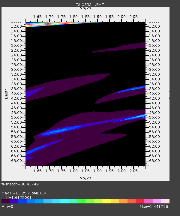
| Estimated Moho Depth: |
11.25 km |
| Estimated Crust Vp/Vs: |
1.62 |
| Assumed Crust Vp: |
6.498 km/s |
| Estimated Crust Vs: |
4.017 km/s |
| Estimated Crust Poisson's Ratio: |
0.19 |
|
| Radial Match: |
80.43749 % |
| Radial Bump: |
400 |
| Transverse Match: |
81.04305 % |
| Transverse Bump: |
272 |
| SOD ConfigId: |
356183 |
| Insert Time: |
2011-08-11 09:00:03.763 +0000 |
| GWidth: |
2.5 |
| Max Bumps: |
400 |
| Tol: |
0.001 |
|
Signal To Noise
| Channel | StoN | STA | LTA |
| TA:O33A: :BHZ:20110311T07:14:49.650015Z | 1.5036137 | 9.5038835E-5 | 6.320695E-5 |
| TA:O33A: :BHN:20110311T07:14:49.650015Z | 2.839797 | 4.3167693E-5 | 1.5200979E-5 |
| TA:O33A: :BHE:20110311T07:14:49.650015Z | 0.801962 | 2.2604234E-5 | 2.8186165E-5 |
| Arrivals |
| Ps | 1.1 SECOND |
| PpPs | 4.4 SECOND |
| PsPs/PpSs | 5.5 SECOND |


