You are here: Home > Network List > TA - USArray Transportable Network (new EarthScope stations) Stations List
> Station N33A J Bar K, Exeter, NE, USA > Earthquake Result Viewer
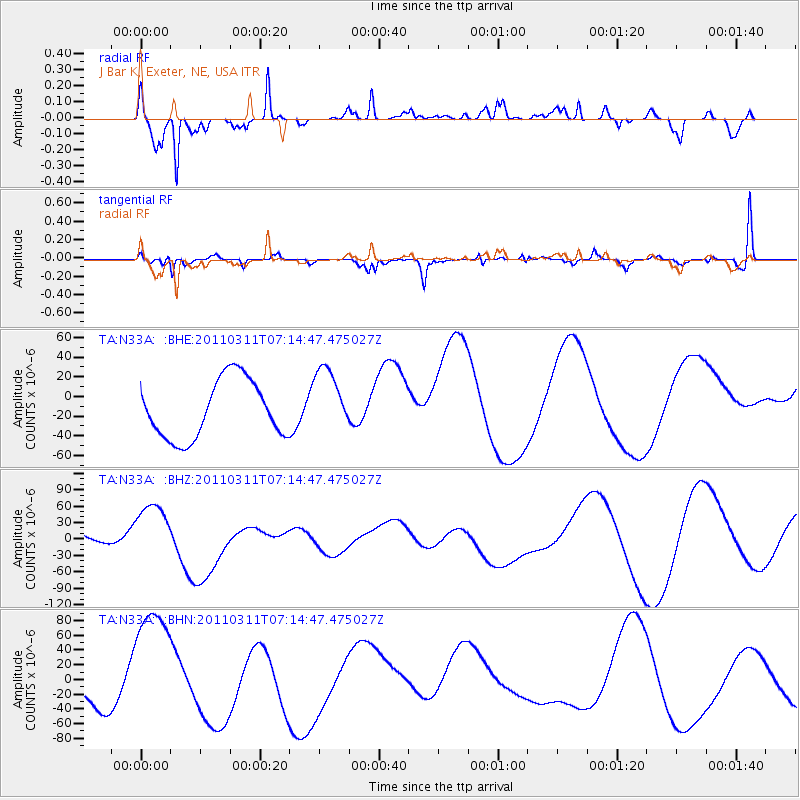
N33A J Bar K, Exeter, NE, USA - Earthquake Result Viewer
*The percent match for this event was below the threshold and hence no stack was calculated.
| Earthquake location: |
Near East Coast Of Honshu, Japan |
| Earthquake latitude/longitude: |
39.7/142.5 |
| Earthquake time(UTC): |
2011/03/11 (070) 07:02:57 GMT |
| Earthquake Depth: |
42 km |
| Earthquake Magnitude: |
5.8 MB |
| Earthquake Catalog/Contributor: |
WHDF/NEIC |
|
| Network: |
TA USArray Transportable Network (new EarthScope stations) |
| Station: |
N33A J Bar K, Exeter, NE, USA |
| Lat/Lon: |
40.74 N/97.45 W |
| Elevation: |
475 m |
|
| Distance: |
83.1 deg |
| Az: |
41.508 deg |
| Baz: |
317.705 deg |
| Ray Param: |
$rayparam |
*The percent match for this event was below the threshold and hence was not used in the summary stack. |
|
| Radial Match: |
46.788708 % |
| Radial Bump: |
301 |
| Transverse Match: |
45.860786 % |
| Transverse Bump: |
323 |
| SOD ConfigId: |
356183 |
| Insert Time: |
2011-08-11 09:01:42.305 +0000 |
| GWidth: |
2.5 |
| Max Bumps: |
400 |
| Tol: |
0.001 |
|
Signal To Noise
| Channel | StoN | STA | LTA |
| TA:N33A: :BHZ:20110311T07:14:47.475027Z | 1.1497782 | 5.2718064E-5 | 4.5850633E-5 |
| TA:N33A: :BHN:20110311T07:14:47.475027Z | 2.7472103 | 8.55785E-5 | 3.1151052E-5 |
| TA:N33A: :BHE:20110311T07:14:47.475027Z | 1.1460553 | 3.370148E-5 | 2.9406503E-5 |
| Arrivals |
| Ps | |
| PpPs | |
| PsPs/PpSs | |


