You are here: Home > Network List > TA - USArray Transportable Network (new EarthScope stations) Stations List
> Station C36A Pine Crest Fram, Angora, MN, USA > Earthquake Result Viewer
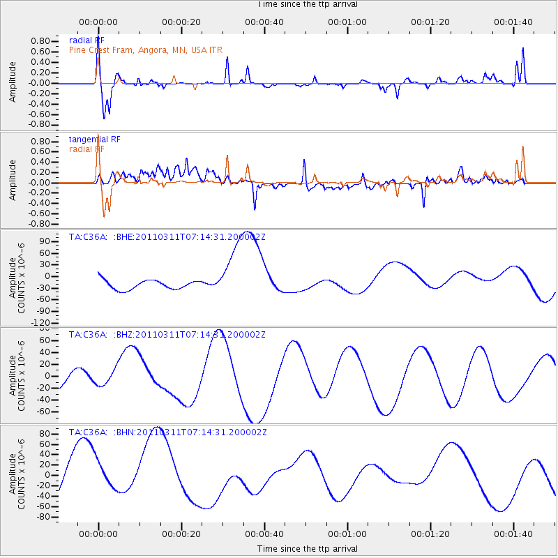
C36A Pine Crest Fram, Angora, MN, USA - Earthquake Result Viewer
*The percent match for this event was below the threshold and hence no stack was calculated.
| Earthquake location: |
Near East Coast Of Honshu, Japan |
| Earthquake latitude/longitude: |
39.7/142.5 |
| Earthquake time(UTC): |
2011/03/11 (070) 07:02:57 GMT |
| Earthquake Depth: |
42 km |
| Earthquake Magnitude: |
5.8 MB |
| Earthquake Catalog/Contributor: |
WHDF/NEIC |
|
| Network: |
TA USArray Transportable Network (new EarthScope stations) |
| Station: |
C36A Pine Crest Fram, Angora, MN, USA |
| Lat/Lon: |
47.76 N/92.84 W |
| Elevation: |
410 m |
|
| Distance: |
80.0 deg |
| Az: |
34.315 deg |
| Baz: |
319.86 deg |
| Ray Param: |
$rayparam |
*The percent match for this event was below the threshold and hence was not used in the summary stack. |
|
| Radial Match: |
55.318737 % |
| Radial Bump: |
400 |
| Transverse Match: |
79.82201 % |
| Transverse Bump: |
400 |
| SOD ConfigId: |
356183 |
| Insert Time: |
2011-08-11 09:08:40.394 +0000 |
| GWidth: |
2.5 |
| Max Bumps: |
400 |
| Tol: |
0.001 |
|
Signal To Noise
| Channel | StoN | STA | LTA |
| TA:C36A: :BHZ:20110311T07:14:31.200002Z | 0.5244836 | 1.3596503E-5 | 2.5923599E-5 |
| TA:C36A: :BHN:20110311T07:14:31.200002Z | 1.0766441 | 3.539592E-5 | 3.2876156E-5 |
| TA:C36A: :BHE:20110311T07:14:31.200002Z | 6.712989 | 8.0163154E-5 | 1.19415E-5 |
| Arrivals |
| Ps | |
| PpPs | |
| PsPs/PpSs | |


