You are here: Home > Network List > TA - USArray Transportable Network (new EarthScope stations) Stations List
> Station F32A Veblen, SD, USA > Earthquake Result Viewer
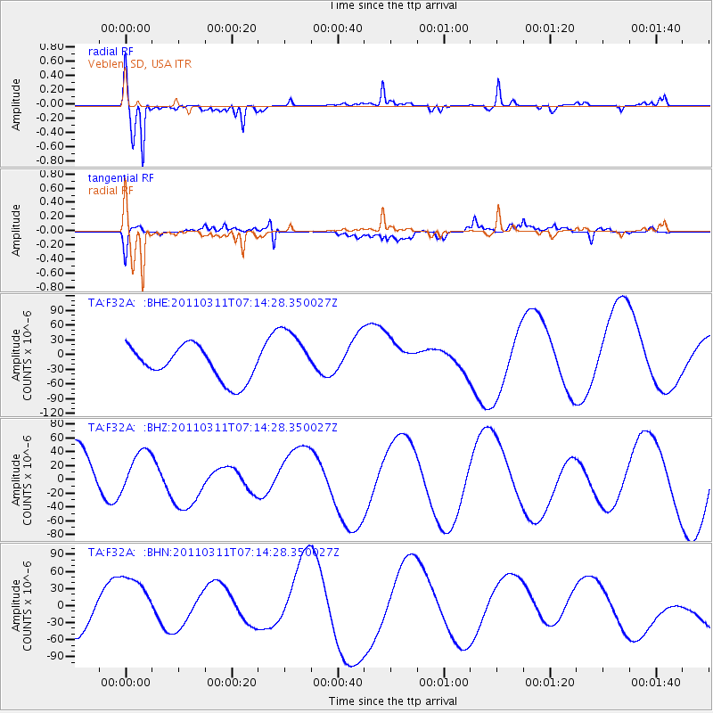
F32A Veblen, SD, USA - Earthquake Result Viewer
*The percent match for this event was below the threshold and hence no stack was calculated.
| Earthquake location: |
Near East Coast Of Honshu, Japan |
| Earthquake latitude/longitude: |
39.7/142.5 |
| Earthquake time(UTC): |
2011/03/11 (070) 07:02:57 GMT |
| Earthquake Depth: |
42 km |
| Earthquake Magnitude: |
5.8 MB |
| Earthquake Catalog/Contributor: |
WHDF/NEIC |
|
| Network: |
TA USArray Transportable Network (new EarthScope stations) |
| Station: |
F32A Veblen, SD, USA |
| Lat/Lon: |
45.87 N/97.13 W |
| Elevation: |
371 m |
|
| Distance: |
79.5 deg |
| Az: |
37.828 deg |
| Baz: |
317.368 deg |
| Ray Param: |
$rayparam |
*The percent match for this event was below the threshold and hence was not used in the summary stack. |
|
| Radial Match: |
69.45328 % |
| Radial Bump: |
282 |
| Transverse Match: |
34.99432 % |
| Transverse Bump: |
353 |
| SOD ConfigId: |
356183 |
| Insert Time: |
2011-08-11 09:10:40.017 +0000 |
| GWidth: |
2.5 |
| Max Bumps: |
400 |
| Tol: |
0.001 |
|
Signal To Noise
| Channel | StoN | STA | LTA |
| TA:F32A: :BHZ:20110311T07:14:28.350027Z | 0.4217622 | 2.819278E-5 | 6.6845205E-5 |
| TA:F32A: :BHN:20110311T07:14:28.350027Z | 2.0571415 | 5.3376265E-5 | 2.5946812E-5 |
| TA:F32A: :BHE:20110311T07:14:28.350027Z | 1.686631 | 5.7163492E-5 | 3.3892116E-5 |
| Arrivals |
| Ps | |
| PpPs | |
| PsPs/PpSs | |


