You are here: Home > Network List > TA - USArray Transportable Network (new EarthScope stations) Stations List
> Station J05D Fort Rock, OR, USA > Earthquake Result Viewer
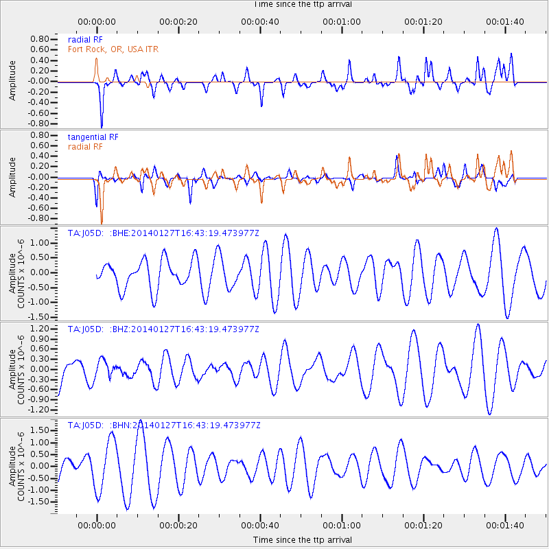
J05D Fort Rock, OR, USA - Earthquake Result Viewer
*The percent match for this event was below the threshold and hence no stack was calculated.
| Earthquake location: |
Santa Cruz Islands |
| Earthquake latitude/longitude: |
-11.9/165.3 |
| Earthquake time(UTC): |
2014/01/27 (027) 16:31:12 GMT |
| Earthquake Depth: |
35 km |
| Earthquake Magnitude: |
5.2 MW |
| Earthquake Catalog/Contributor: |
ISC/ISC |
|
| Network: |
TA USArray Transportable Network (new EarthScope stations) |
| Station: |
J05D Fort Rock, OR, USA |
| Lat/Lon: |
43.28 N/121.23 W |
| Elevation: |
1541 m |
|
| Distance: |
86.3 deg |
| Az: |
44.543 deg |
| Baz: |
250.093 deg |
| Ray Param: |
$rayparam |
*The percent match for this event was below the threshold and hence was not used in the summary stack. |
|
| Radial Match: |
71.234825 % |
| Radial Bump: |
400 |
| Transverse Match: |
40.964058 % |
| Transverse Bump: |
341 |
| SOD ConfigId: |
3390531 |
| Insert Time: |
2019-04-10 03:47:05.639 +0000 |
| GWidth: |
2.5 |
| Max Bumps: |
400 |
| Tol: |
0.001 |
|
Signal To Noise
| Channel | StoN | STA | LTA |
| TA:J05D: :BHZ:20140127T16:43:19.473977Z | 0.515416 | 2.5852654E-7 | 5.015881E-7 |
| TA:J05D: :BHN:20140127T16:43:19.473977Z | 2.010772 | 1.0845032E-6 | 5.393467E-7 |
| TA:J05D: :BHE:20140127T16:43:19.473977Z | 1.2043976 | 5.577639E-7 | 4.6310615E-7 |
| Arrivals |
| Ps | |
| PpPs | |
| PsPs/PpSs | |


