You are here: Home > Network List > AV - Alaska Volcano Observatory Stations List
> Station SPCR Ckakachatna River, Mount Spurr, Alaska > Earthquake Result Viewer
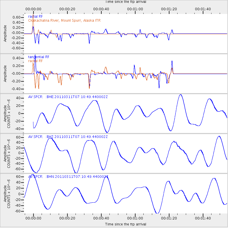
SPCR Ckakachatna River, Mount Spurr, Alaska - Earthquake Result Viewer
*The percent match for this event was below the threshold and hence no stack was calculated.
| Earthquake location: |
Off East Coast Of Honshu, Japan |
| Earthquake latitude/longitude: |
37.9/142.8 |
| Earthquake time(UTC): |
2011/03/11 (070) 07:03:00 GMT |
| Earthquake Depth: |
19 km |
| Earthquake Magnitude: |
5.6 MB |
| Earthquake Catalog/Contributor: |
WHDF/NEIC |
|
| Network: |
AV Alaska Volcano Observatory |
| Station: |
SPCR Ckakachatna River, Mount Spurr, Alaska |
| Lat/Lon: |
61.20 N/152.21 W |
| Elevation: |
984 m |
|
| Distance: |
45.8 deg |
| Az: |
37.756 deg |
| Baz: |
270.308 deg |
| Ray Param: |
$rayparam |
*The percent match for this event was below the threshold and hence was not used in the summary stack. |
|
| Radial Match: |
82.371895 % |
| Radial Bump: |
400 |
| Transverse Match: |
48.385857 % |
| Transverse Bump: |
128 |
| SOD ConfigId: |
356183 |
| Insert Time: |
2011-08-11 09:42:48.354 +0000 |
| GWidth: |
2.5 |
| Max Bumps: |
400 |
| Tol: |
0.001 |
|
Signal To Noise
| Channel | StoN | STA | LTA |
| AV:SPCR: :BHZ:20110311T07:10:49.440002Z | 2.527192 | 6.9372705E-5 | 2.745051E-5 |
| AV:SPCR: :BHN:20110311T07:10:49.440002Z | 2.2326522 | 5.4983208E-5 | 2.4626857E-5 |
| AV:SPCR: :BHE:20110311T07:10:49.440002Z | 1.0453722 | 1.9743444E-5 | 1.888652E-5 |
| Arrivals |
| Ps | |
| PpPs | |
| PsPs/PpSs | |


