You are here: Home > Network List > TA - USArray Transportable Network (new EarthScope stations) Stations List
> Station H34A Spellman Lake, Hanley Falls, MN, USA > Earthquake Result Viewer
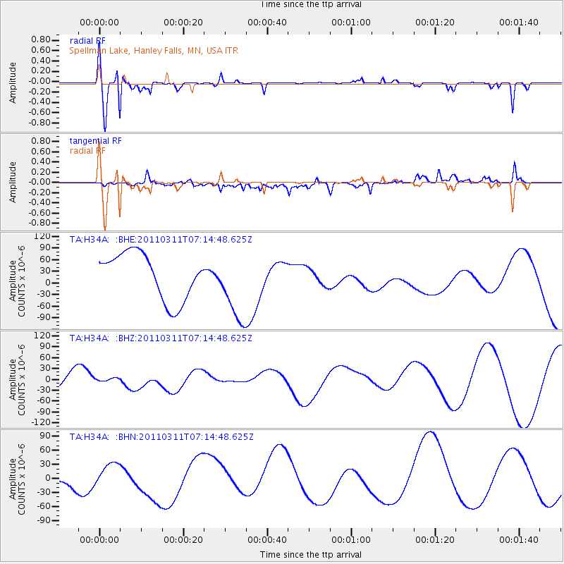
H34A Spellman Lake, Hanley Falls, MN, USA - Earthquake Result Viewer
*The percent match for this event was below the threshold and hence no stack was calculated.
| Earthquake location: |
Off East Coast Of Honshu, Japan |
| Earthquake latitude/longitude: |
37.9/142.8 |
| Earthquake time(UTC): |
2011/03/11 (070) 07:03:00 GMT |
| Earthquake Depth: |
19 km |
| Earthquake Magnitude: |
5.6 MB |
| Earthquake Catalog/Contributor: |
WHDF/NEIC |
|
| Network: |
TA USArray Transportable Network (new EarthScope stations) |
| Station: |
H34A Spellman Lake, Hanley Falls, MN, USA |
| Lat/Lon: |
44.67 N/95.78 W |
| Elevation: |
329 m |
|
| Distance: |
82.3 deg |
| Az: |
37.917 deg |
| Baz: |
317.074 deg |
| Ray Param: |
$rayparam |
*The percent match for this event was below the threshold and hence was not used in the summary stack. |
|
| Radial Match: |
58.471874 % |
| Radial Bump: |
364 |
| Transverse Match: |
46.116276 % |
| Transverse Bump: |
400 |
| SOD ConfigId: |
356183 |
| Insert Time: |
2011-08-11 10:44:19.102 +0000 |
| GWidth: |
2.5 |
| Max Bumps: |
400 |
| Tol: |
0.001 |
|
Signal To Noise
| Channel | StoN | STA | LTA |
| TA:H34A: :BHZ:20110311T07:14:48.625Z | 0.2365521 | 5.5570627E-6 | 2.3491917E-5 |
| TA:H34A: :BHN:20110311T07:14:48.625Z | 0.6621452 | 1.8037857E-5 | 2.7241544E-5 |
| TA:H34A: :BHE:20110311T07:14:48.625Z | 1.5824593 | 9.427849E-5 | 5.9577196E-5 |
| Arrivals |
| Ps | |
| PpPs | |
| PsPs/PpSs | |


