You are here: Home > Network List > TA - USArray Transportable Network (new EarthScope stations) Stations List
> Station D37A Cotton, MN, USA > Earthquake Result Viewer
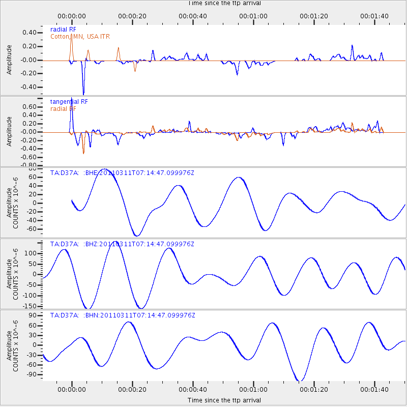
D37A Cotton, MN, USA - Earthquake Result Viewer
*The percent match for this event was below the threshold and hence no stack was calculated.
| Earthquake location: |
Off East Coast Of Honshu, Japan |
| Earthquake latitude/longitude: |
37.9/142.8 |
| Earthquake time(UTC): |
2011/03/11 (070) 07:03:00 GMT |
| Earthquake Depth: |
19 km |
| Earthquake Magnitude: |
5.6 MB |
| Earthquake Catalog/Contributor: |
WHDF/NEIC |
|
| Network: |
TA USArray Transportable Network (new EarthScope stations) |
| Station: |
D37A Cotton, MN, USA |
| Lat/Lon: |
47.16 N/92.43 W |
| Elevation: |
413 m |
|
| Distance: |
82.0 deg |
| Az: |
34.479 deg |
| Baz: |
319.002 deg |
| Ray Param: |
$rayparam |
*The percent match for this event was below the threshold and hence was not used in the summary stack. |
|
| Radial Match: |
79.26101 % |
| Radial Bump: |
400 |
| Transverse Match: |
76.00263 % |
| Transverse Bump: |
400 |
| SOD ConfigId: |
356183 |
| Insert Time: |
2011-08-11 10:51:28.468 +0000 |
| GWidth: |
2.5 |
| Max Bumps: |
400 |
| Tol: |
0.001 |
|
Signal To Noise
| Channel | StoN | STA | LTA |
| TA:D37A: :BHZ:20110311T07:14:47.099976Z | 4.429343 | 9.1705726E-5 | 2.0704138E-5 |
| TA:D37A: :BHN:20110311T07:14:47.099976Z | 0.26407045 | 9.840283E-6 | 3.7263857E-5 |
| TA:D37A: :BHE:20110311T07:14:47.099976Z | 0.3803718 | 1.9084211E-5 | 5.017252E-5 |
| Arrivals |
| Ps | |
| PpPs | |
| PsPs/PpSs | |


