You are here: Home > Network List > TA - USArray Transportable Network (new EarthScope stations) Stations List
> Station E62A Clayton Lake, ME, USA > Earthquake Result Viewer
E62A Clayton Lake, ME, USA - Earthquake Result Viewer
*The percent match for this event was below the threshold and hence no stack was calculated.
| Earthquake location: |
Southern Bolivia |
| Earthquake latitude/longitude: |
-19.3/-63.9 |
| Earthquake time(UTC): |
2014/01/27 (027) 16:42:37 GMT |
| Earthquake Depth: |
600 km |
| Earthquake Magnitude: |
5.6 MWB |
| Earthquake Catalog/Contributor: |
NEIC PDE/NEIC COMCAT |
|
| Network: |
TA USArray Transportable Network (new EarthScope stations) |
| Station: |
E62A Clayton Lake, ME, USA |
| Lat/Lon: |
46.62 N/69.52 W |
| Elevation: |
356 m |
|
| Distance: |
65.8 deg |
| Az: |
355.767 deg |
| Baz: |
174.194 deg |
| Ray Param: |
$rayparam |
*The percent match for this event was below the threshold and hence was not used in the summary stack. |
|
| Radial Match: |
51.560467 % |
| Radial Bump: |
400 |
| Transverse Match: |
65.12835 % |
| Transverse Bump: |
400 |
| SOD ConfigId: |
3390531 |
| Insert Time: |
2019-04-10 03:51:50.353 +0000 |
| GWidth: |
2.5 |
| Max Bumps: |
400 |
| Tol: |
0.001 |
|
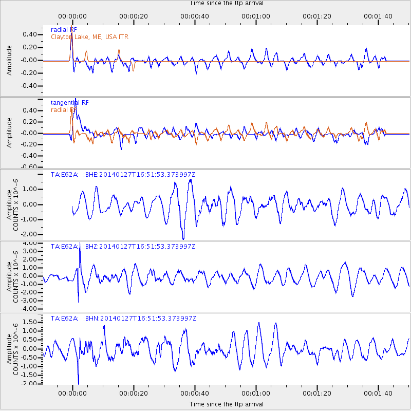
Signal To Noise
| Channel | StoN | STA | LTA |
| TA:E62A: :BHZ:20140127T16:51:53.373997Z | 2.644892 | 1.3236724E-6 | 5.004637E-7 |
| TA:E62A: :BHN:20140127T16:51:53.373997Z | 0.96284395 | 5.430757E-7 | 5.640329E-7 |
| TA:E62A: :BHE:20140127T16:51:53.373997Z | 1.7409039 | 8.893225E-7 | 5.108395E-7 |
| Arrivals |
| Ps | |
| PpPs | |
| PsPs/PpSs | |


