You are here: Home > Network List > TA - USArray Transportable Network (new EarthScope stations) Stations List
> Station R30A Dighton, KS, USA > Earthquake Result Viewer
R30A Dighton, KS, USA - Earthquake Result Viewer
| Earthquake location: |
Near East Coast Of Honshu, Japan |
| Earthquake latitude/longitude: |
39.0/142.4 |
| Earthquake time(UTC): |
2011/03/11 (070) 07:04:16 GMT |
| Earthquake Depth: |
24 km |
| Earthquake Magnitude: |
5.8 MB |
| Earthquake Catalog/Contributor: |
WHDF/NEIC |
|
| Network: |
TA USArray Transportable Network (new EarthScope stations) |
| Station: |
R30A Dighton, KS, USA |
| Lat/Lon: |
38.28 N/100.28 W |
| Elevation: |
776 m |
|
| Distance: |
84.0 deg |
| Az: |
44.67 deg |
| Baz: |
315.858 deg |
| Ray Param: |
0.045773607 |
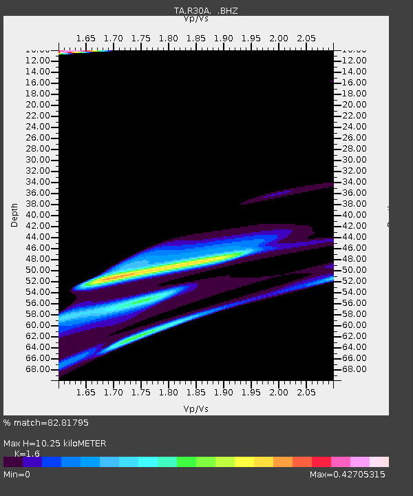
| Estimated Moho Depth: |
10.25 km |
| Estimated Crust Vp/Vs: |
1.60 |
| Assumed Crust Vp: |
6.483 km/s |
| Estimated Crust Vs: |
4.052 km/s |
| Estimated Crust Poisson's Ratio: |
0.18 |
|
| Radial Match: |
82.81795 % |
| Radial Bump: |
400 |
| Transverse Match: |
58.43878 % |
| Transverse Bump: |
386 |
| SOD ConfigId: |
356183 |
| Insert Time: |
2011-08-11 12:22:24.495 +0000 |
| GWidth: |
2.5 |
| Max Bumps: |
400 |
| Tol: |
0.001 |
|
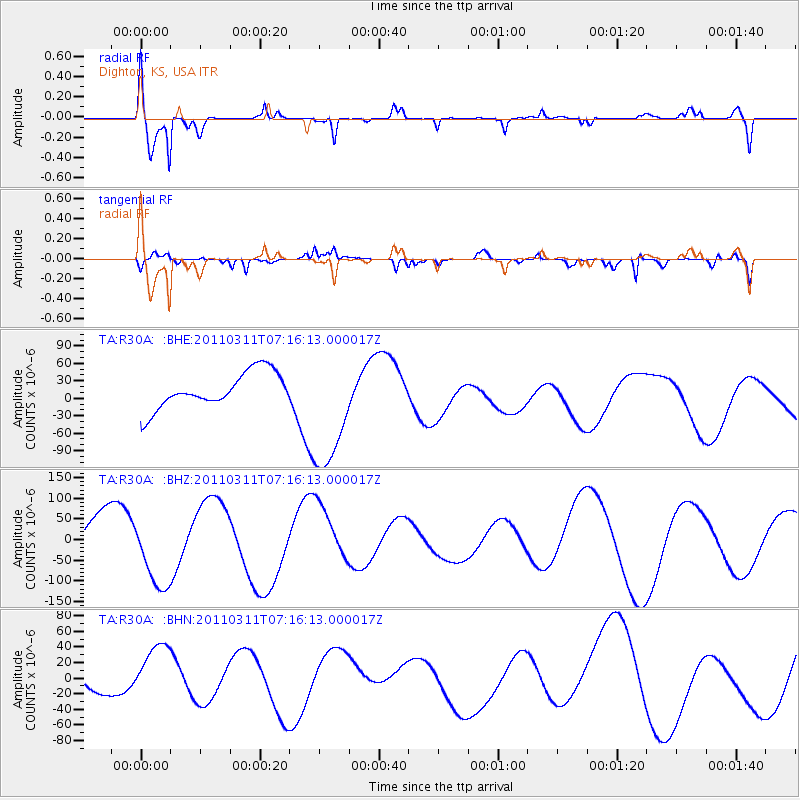
Signal To Noise
| Channel | StoN | STA | LTA |
| TA:R30A: :BHZ:20110311T07:16:13.000017Z | 1.7968658 | 8.48273E-5 | 4.7208476E-5 |
| TA:R30A: :BHN:20110311T07:16:13.000017Z | 1.3324354 | 3.5411194E-5 | 2.6576294E-5 |
| TA:R30A: :BHE:20110311T07:16:13.000017Z | 3.503491 | 1.0733471E-4 | 3.06365E-5 |
| Arrivals |
| Ps | 1.0 SECOND |
| PpPs | 4.0 SECOND |
| PsPs/PpSs | 5.0 SECOND |


