You are here: Home > Network List > TA - USArray Transportable Network (new EarthScope stations) Stations List
> Station B27A Peters Farms, Glenburn, ND, USA > Earthquake Result Viewer
B27A Peters Farms, Glenburn, ND, USA - Earthquake Result Viewer
| Earthquake location: |
Near East Coast Of Honshu, Japan |
| Earthquake latitude/longitude: |
39.0/142.4 |
| Earthquake time(UTC): |
2011/03/11 (070) 07:04:16 GMT |
| Earthquake Depth: |
24 km |
| Earthquake Magnitude: |
5.8 MB |
| Earthquake Catalog/Contributor: |
WHDF/NEIC |
|
| Network: |
TA USArray Transportable Network (new EarthScope stations) |
| Station: |
B27A Peters Farms, Glenburn, ND, USA |
| Lat/Lon: |
48.40 N/101.26 W |
| Elevation: |
492 m |
|
| Distance: |
76.3 deg |
| Az: |
37.922 deg |
| Baz: |
314.025 deg |
| Ray Param: |
0.051045097 |
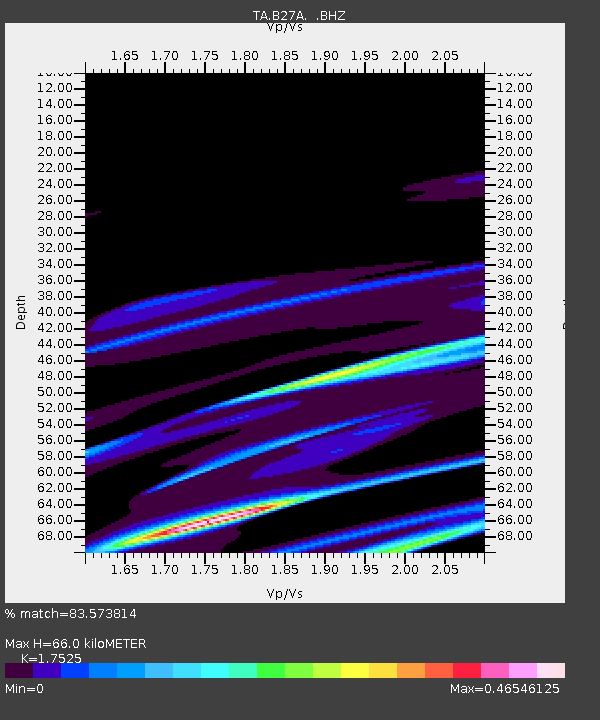
| Estimated Moho Depth: |
66.0 km |
| Estimated Crust Vp/Vs: |
1.75 |
| Assumed Crust Vp: |
6.438 km/s |
| Estimated Crust Vs: |
3.673 km/s |
| Estimated Crust Poisson's Ratio: |
0.26 |
|
| Radial Match: |
83.573814 % |
| Radial Bump: |
400 |
| Transverse Match: |
48.475723 % |
| Transverse Bump: |
400 |
| SOD ConfigId: |
356183 |
| Insert Time: |
2011-08-11 12:27:58.426 +0000 |
| GWidth: |
2.5 |
| Max Bumps: |
400 |
| Tol: |
0.001 |
|

Signal To Noise
| Channel | StoN | STA | LTA |
| TA:B27A: :BHZ:20110311T07:15:31.849993Z | 1.7323976 | 1.355296E-4 | 7.823239E-5 |
| TA:B27A: :BHN:20110311T07:15:31.849993Z | 0.84306127 | 4.2863718E-5 | 5.0842948E-5 |
| TA:B27A: :BHE:20110311T07:15:31.849993Z | 1.3976651 | 1.0912292E-4 | 7.807515E-5 |
| Arrivals |
| Ps | 8.0 SECOND |
| PpPs | 27 SECOND |
| PsPs/PpSs | 35 SECOND |


