You are here: Home > Network List > TA - USArray Transportable Network (new EarthScope stations) Stations List
> Station 434A Burnet, TX, USA > Earthquake Result Viewer
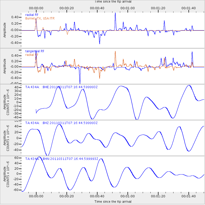
434A Burnet, TX, USA - Earthquake Result Viewer
*The percent match for this event was below the threshold and hence no stack was calculated.
| Earthquake location: |
Near East Coast Of Honshu, Japan |
| Earthquake latitude/longitude: |
39.0/142.4 |
| Earthquake time(UTC): |
2011/03/11 (070) 07:04:16 GMT |
| Earthquake Depth: |
24 km |
| Earthquake Magnitude: |
5.8 MB |
| Earthquake Catalog/Contributor: |
WHDF/NEIC |
|
| Network: |
TA USArray Transportable Network (new EarthScope stations) |
| Station: |
434A Burnet, TX, USA |
| Lat/Lon: |
30.81 N/98.27 W |
| Elevation: |
462 m |
|
| Distance: |
90.5 deg |
| Az: |
48.596 deg |
| Baz: |
317.182 deg |
| Ray Param: |
$rayparam |
*The percent match for this event was below the threshold and hence was not used in the summary stack. |
|
| Radial Match: |
76.46845 % |
| Radial Bump: |
254 |
| Transverse Match: |
55.344257 % |
| Transverse Bump: |
326 |
| SOD ConfigId: |
356183 |
| Insert Time: |
2011-08-11 12:33:19.388 +0000 |
| GWidth: |
2.5 |
| Max Bumps: |
400 |
| Tol: |
0.001 |
|
Signal To Noise
| Channel | StoN | STA | LTA |
| TA:434A: :BHZ:20110311T07:16:44.599993Z | 0.7579127 | 2.6087497E-5 | 3.4420187E-5 |
| TA:434A: :BHN:20110311T07:16:44.599993Z | 1.6219417 | 6.7668785E-5 | 4.172085E-5 |
| TA:434A: :BHE:20110311T07:16:44.599993Z | 1.3088032 | 2.6546171E-5 | 2.0282783E-5 |
| Arrivals |
| Ps | |
| PpPs | |
| PsPs/PpSs | |


