You are here: Home > Network List > TA - USArray Transportable Network (new EarthScope stations) Stations List
> Station R37A Teagarden Farms, La Cygne, KS, USA > Earthquake Result Viewer
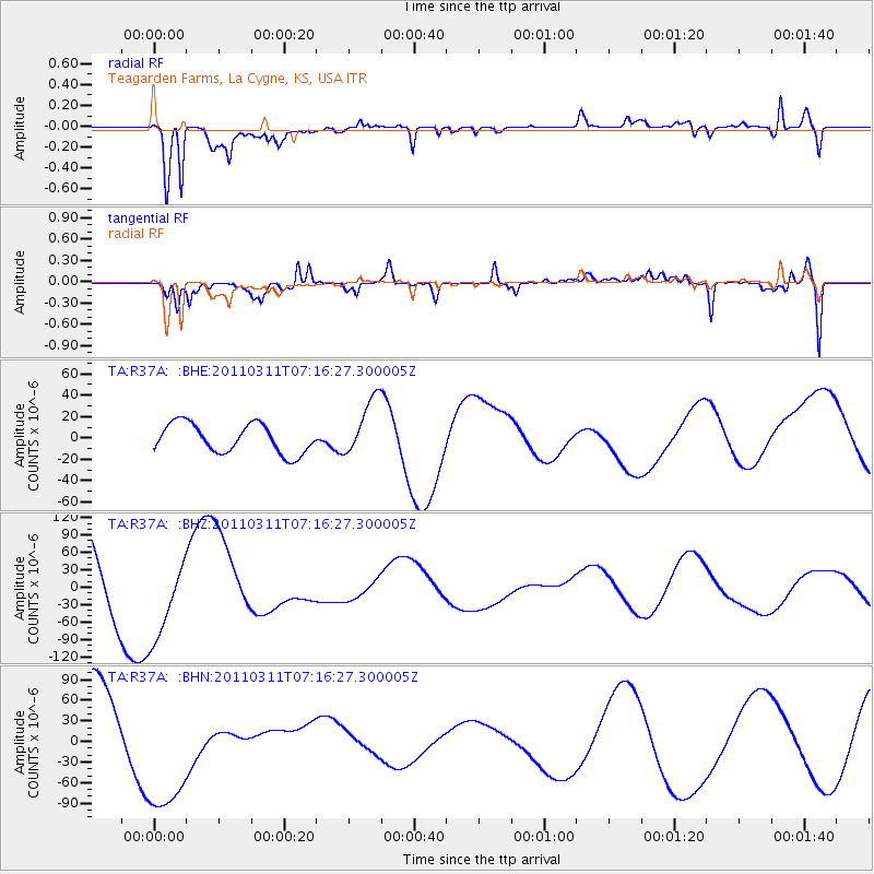
R37A Teagarden Farms, La Cygne, KS, USA - Earthquake Result Viewer
*The percent match for this event was below the threshold and hence no stack was calculated.
| Earthquake location: |
Near East Coast Of Honshu, Japan |
| Earthquake latitude/longitude: |
39.0/142.4 |
| Earthquake time(UTC): |
2011/03/11 (070) 07:04:16 GMT |
| Earthquake Depth: |
24 km |
| Earthquake Magnitude: |
5.8 MB |
| Earthquake Catalog/Contributor: |
WHDF/NEIC |
|
| Network: |
TA USArray Transportable Network (new EarthScope stations) |
| Station: |
R37A Teagarden Farms, La Cygne, KS, USA |
| Lat/Lon: |
38.31 N/94.83 W |
| Elevation: |
298 m |
|
| Distance: |
86.9 deg |
| Az: |
41.485 deg |
| Baz: |
318.967 deg |
| Ray Param: |
$rayparam |
*The percent match for this event was below the threshold and hence was not used in the summary stack. |
|
| Radial Match: |
75.73228 % |
| Radial Bump: |
400 |
| Transverse Match: |
58.514782 % |
| Transverse Bump: |
400 |
| SOD ConfigId: |
356183 |
| Insert Time: |
2011-08-11 12:37:34.892 +0000 |
| GWidth: |
2.5 |
| Max Bumps: |
400 |
| Tol: |
0.001 |
|
Signal To Noise
| Channel | StoN | STA | LTA |
| TA:R37A: :BHZ:20110311T07:16:27.300005Z | 1.2759279 | 7.486137E-5 | 5.8672096E-5 |
| TA:R37A: :BHN:20110311T07:16:27.300005Z | 1.74641 | 1.11760644E-4 | 6.399451E-5 |
| TA:R37A: :BHE:20110311T07:16:27.300005Z | 2.0181978 | 2.7482278E-5 | 1.36172375E-5 |
| Arrivals |
| Ps | |
| PpPs | |
| PsPs/PpSs | |


